Lembar elevation
Lembar (West Nusa Tenggara), Indonesia elevation is 7 meters and Lembar elevation in feet is 23 ft above sea level [src 1]. Lembar is a populated place (feature code) with elevation that is 184 meters (604 ft) smaller than average city elevation in Indonesia.
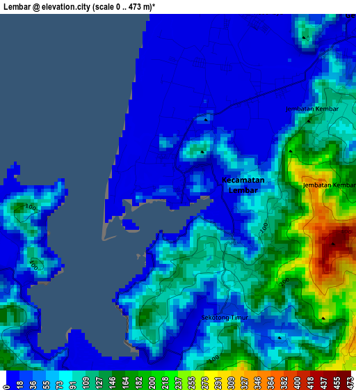
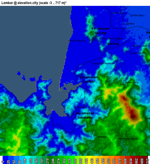
Below is the Elevation map of Lembar, which displays elevation range with different colors. Scale of the first map is from 0 to 473 m (0 to 1552 ft) with average elevation of 81.1 meters (=266 ft) [note 1]
These maps also provides idea of topography and contour of this city, they are displayed at different zoom levels. More info about maps, scale and edge coordinates you can find below images.
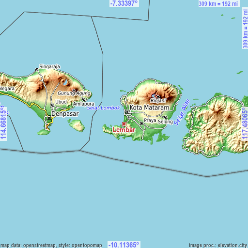
| \ | Map #1 | Map #2 | Topo.Map |
| Scale [m] | 0..473 m | -3..717 m | × |
| Scale [ft] | 0..1552 ft | -10..2352 ft | × |
| Average | 81.1 m = 266 ft | 133.3 m = 437 ft | × |
| Width | 9.66 km = 6 mi | 19.32 km = 12 mi | 309.1 km = 192.1 mi |
| Height | 9.66 km = 6 mi | 19.32 km = 12 mi | 309.1 km = 192.1 mi |
| ↑Max Latitude | -8.682961° | -8.639517° | -7.33397° |
| Latitude at center | -8.7264° | -8.7264° | -8.7264° |
| ↓Min Latitude | -8.769834° | -8.813263° | -10.11365° |
| ← Min Longitude | 116.030455° | 115.986509° | 114.66815° |
| Longitude center | 116.0744° | 116.0744° | 116.0744° |
| →Max Longitude | 116.118345° | 116.162291° | 117.48065° |
Nearby cities:
Cities around Lembar sort by population:
• Mataram elevation 24 m
16.6 km,  16°
16°
• Praya 108 m
21.7 km,  83°
83°
• Senggigi 80 m
26.3 km,  352°
352°
• Pemenang 14 m
36 km,  4°
4°
• Kopang Satu 348 m
32.2 km,  71°
71°
• Mujur 111 m
31.1 km,  97°
97°
• Mantang 357 m
29.1 km,  64°
64°
• Narmada 137 m
20.6 km,  43°
43°
• Karang Daye 93 m
18.5 km, 96°
• Kediri 50 m
13.3 km, 39°
• Gerung 21 m
7.4 km,  49°
49°
• Sekotong Tengah 12 m
6.4 km,  206°
206°
Multilingual:
 En español:
Lembar elevación 7 m.
 En France:
Lembar élévation 7 m.


Sources and notes:
- [note 1] Map square and city borders are not equal. Map elevation data is calculated only from area inside that square.
- [src 1] Elevation data from geonames database provided with same terms of usage.
- [src 2] The elevation map of Lembar is generated using elevation data from NASA's 3 arcsec (90m) resolution SRTM data.
- [src 3] Base (background) map © OpenStreetMap contributors tiles are generated by Geofabrik and OpenTopoMap.
Copyright & License:
This Lembar Elevation Map is licensed under CC BY-SA. You may reuse any part from this page, if you give a proper credit by linking to this URL:
 More info on terms of use page.