Lengkong elevation
Lengkong (West Java), Indonesia elevation is 595 meters and Lengkong elevation in feet is 1952 ft above sea level [src 1]. Lengkong is a seat of a third-order administrative division (feature code) with elevation that is 404 meters (1325 ft) bigger than average city elevation in Indonesia.
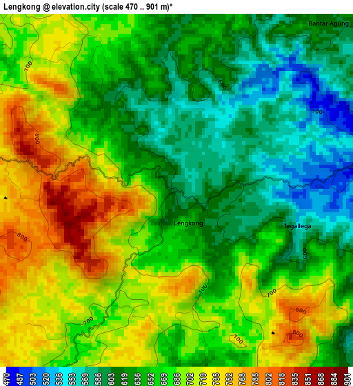
Below is the Elevation map of Lengkong, which displays elevation range with different colors. Scale of the first map is from 470 to 901 m (1542 to 2956 ft) with average elevation of 662.5 meters (=2174 ft) [note 1]
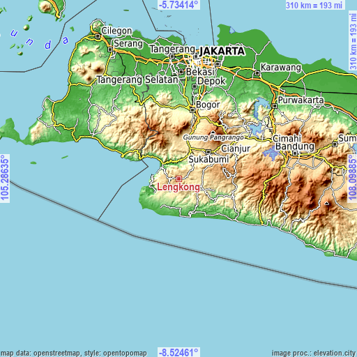
These maps also provides idea of topography and contour of this city, they are displayed at different zoom levels. More info about maps, scale and edge coordinates you can find below images.
| \ | Map #1 | Topo.Map |
| Scale [m] | 470..901 m | × |
| Scale [ft] | 1542..2956 ft | × |
| Average | 662.5 m = 2174 ft | × |
| Width | 9.7 km = 6 mi | 310.3 km = 192.8 mi |
| Height | 9.7 km = 6 mi | 310.3 km = 192.8 mi |
| ↑Max Latitude | -7.087893° | -5.73414° |
| Latitude at center | -7.1315° | -7.1315° |
| ↓Min Latitude | -7.175103° | -8.52461° |
| ← Min Longitude | 106.648655° | 105.28635° |
| Longitude center | 106.6926° | 106.6926° |
| →Max Longitude | 106.736545° | 108.09885° |
Nearby cities:
Cities around Lengkong sort by population:
• Pelabuhanratu elevation 21 m
22.3 km,  315°
315°
• Buniasih 13 m
32.6 km,  174°
174°
• Nyalindung 920 m
29.5 km,  70°
70°
• Ciracap 107 m
29.1 km,  220°
220°
• Surade 118 m
27.5 km,  211°
211°
• Sinarjaya 267 m
24.9 km,  140°
140°
• Sagaranten 376 m
23.3 km,  114°
114°
• Ciemas 321 m
22.2 km,  239°
239°
• Puncaktugu 370 m
17.6 km,  117°
117°
• Jampang Kulon 319 m
15.9 km, 207°
• Kalibunder 353 m
14.9 km, 167°
• Jampang Tengah 518 m
14.6 km,  55°
55°
Multilingual:
 En español:
Lengkong elevación 595 m.
 En France:
Lengkong élévation 595 m.
 Auf Deutsch:
Lengkong höhe über dem Meeresspiegel ist 595 m.

Sources and notes:
- [note 1] Map square and city borders are not equal. Map elevation data is calculated only from area inside that square.
- [src 1] Elevation data from geonames database provided with same terms of usage.
- [src 2] The elevation map of Lengkong is generated using elevation data from NASA's 3 arcsec (90m) resolution SRTM data.
- [src 3] Base (background) map © OpenStreetMap contributors tiles are generated by Geofabrik and OpenTopoMap.
Copyright & License:
This Lengkong Elevation Map is licensed under CC BY-SA. You may reuse any part from this page, if you give a proper credit by linking to this URL:
 More info on terms of use page.