Manismata elevation
Manismata (West Kalimantan), Indonesia elevation is 29 meters and Manismata elevation in feet is 95 ft above sea level [src 1]. Manismata is a populated place (feature code) with elevation that is 162 meters (531 ft) smaller than average city elevation in Indonesia.
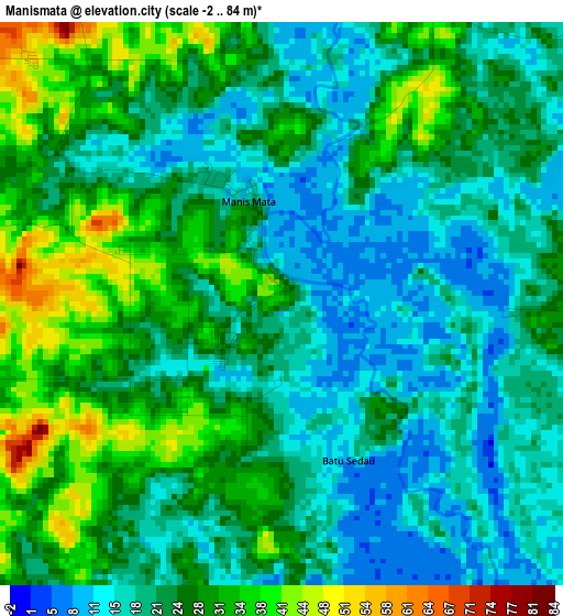
Below is the Elevation map of Manismata, which displays elevation range with different colors. Scale of the first map is from -2 to 84 m (-7 to 276 ft) with average elevation of 23.6 meters (=77 ft) [note 1]
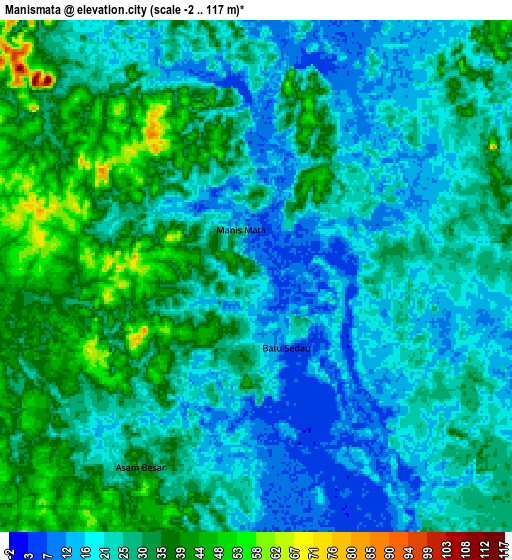
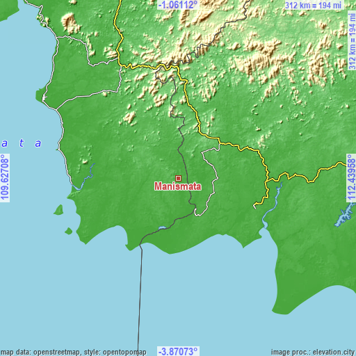
These maps also provides idea of topography and contour of this city, they are displayed at different zoom levels. More info about maps, scale and edge coordinates you can find below images.
| \ | Map #1 | Map #2 | Topo.Map |
| Scale [m] | -2..84 m | -2..117 m | × |
| Scale [ft] | -7..276 ft | -7..384 ft | × |
| Average | 23.6 m = 77 ft | 26.7 m = 88 ft | × |
| Width | 9.76 km = 6.1 mi | 19.53 km = 12.1 mi | 312.4 km = 194.1 mi |
| Height | 9.76 km = 6.1 mi | 19.53 km = 12.1 mi | 312.4 km = 194.1 mi |
| ↑Max Latitude | -2.422765° | -2.378858° | -1.06112° |
| Latitude at center | -2.46667° | -2.46667° | -2.46667° |
| ↓Min Latitude | -2.510574° | -2.554476° | -3.87073° |
| ← Min Longitude | 110.989385° | 110.945439° | 109.62708° |
| Longitude center | 111.03333° | 111.03333° | 111.03333° |
| →Max Longitude | 111.077275° | 111.121221° | 112.43958° |
Nearby cities:
Cities around Manismata sort by population:
• Sampit elevation 5 m
213 km,  91°
91°
• Pangkalanbuun 16 m
70.1 km,  110°
110°
• Kuala Pembuang 5 m
197.4 km,  121°
121°
• Kenyau 48 m
184.4 km,  341°
341°
• Sukadana 5 m
181.1 km,  318°
318°
• Rantaupulut 40 m
138.8 km,  68°
68°
• Ketapang 4 m
136.5 km,  300°
300°
• Semilat 28 m
132.1 km,  82°
82°
• Pembuanghulu 24 m
124.3 km, 92°
• Kumai 5 m
82.7 km, 111°
• Nanga Bulik 21 m
60.8 km,  56°
56°
• Kotawaringin 21 m
48.9 km, 90°
Multilingual:
 En español:
Manismata elevación 29 m.
 En France:
Manismata élévation 29 m.
 Auf Deutsch:
Manismata höhe über dem Meeresspiegel ist 29 m.

Sources and notes:
- [note 1] Map square and city borders are not equal. Map elevation data is calculated only from area inside that square.
- [src 1] Elevation data from geonames database provided with same terms of usage.
- [src 2] The elevation map of Manismata is generated using elevation data from NASA's 3 arcsec (90m) resolution SRTM data.
- [src 3] Base (background) map © OpenStreetMap contributors tiles are generated by Geofabrik and OpenTopoMap.
Copyright & License:
This Manismata Elevation Map is licensed under CC BY-SA. You may reuse any part from this page, if you give a proper credit by linking to this URL:
 More info on terms of use page.