Manokwari elevation
Manokwari (West Papua, Kabupaten Manokwari), Indonesia elevation is 15 meters and Manokwari elevation in feet is 49 ft above sea level [src 1]. Manokwari is a seat of a first-order administrative division (feature code) with elevation that is 176 meters (577 ft) smaller than average city elevation in Indonesia.
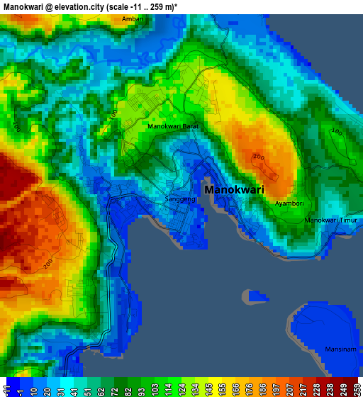
Below is the Elevation map of Manokwari, which displays elevation range with different colors. Scale of the first map is from -11 to 259 m (-36 to 850 ft) with average elevation of 83.7 meters (=275 ft) [note 1]
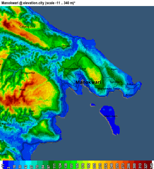
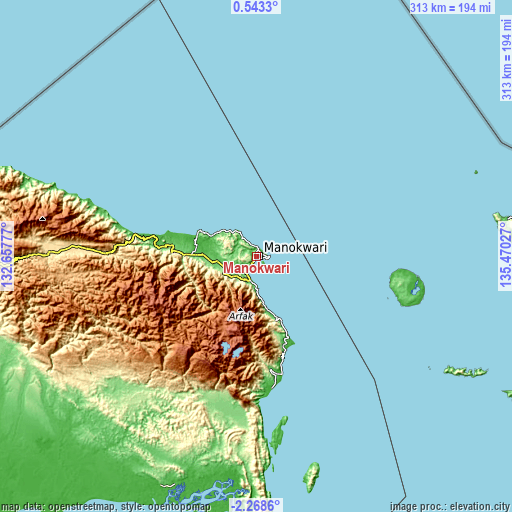
These maps also provides idea of topography and contour of this city, they are displayed at different zoom levels. More info about maps, scale and edge coordinates you can find below images.
| \ | Map #1 | Map #2 | Topo.Map |
| Scale [m] | -11..259 m | -11..340 m | × |
| Scale [ft] | -36..850 ft | -36..1115 ft | × |
| Average | 83.7 m = 275 ft | 104.3 m = 342 ft | × |
| Width | 9.77 km = 6.1 mi | 19.54 km = 12.1 mi | 312.7 km = 194.3 mi |
| Height | 9.77 km = 6.1 mi | 19.54 km = 12.1 mi | 312.7 km = 194.3 mi |
| ↑Max Latitude | -0.818969° | -0.775028° | 0.5433° |
| Latitude at center | -0.86291° | -0.86291° | -0.86291° |
| ↓Min Latitude | -0.90685° | -0.95079° | -2.2686° |
| ← Min Longitude | 134.020075° | 133.976129° | 132.65777° |
| Longitude center | 134.06402° | 134.06402° | 134.06402° |
| →Max Longitude | 134.107965° | 134.151911° | 135.47027° |
Nearby cities:
Cities around Manokwari sort by population:
• Kumurkek elevation 446 m
179.3 km,  255°
255°
• Aifat 511 m
177 km, 259°
• Korido 12 m
174.6 km,  90°
90°
• Bintuni 95 m
150.4 km,  202°
202°
• Merdey 189 m
119.3 km,  221°
221°
• Saukorem 19 m
106.6 km,  288°
288°
• Kebar 584 m
102.1 km,  270°
270°
• Kameri 1 m
83.4 km,  99°
99°
• Ransiki 26 m
72.7 km,  170°
170°
• Ullong 1953 m
58.9 km, 196°
• Oransbari 11 m
57.7 km,  157°
157°
• Warmare 1506 m
31.4 km,  206°
206°
Multilingual:
 En español:
Manokwari elevación 15 m.
 En France:
Manokwari élévation 15 m.
 Auf Deutsch:
Manokwari höhe über dem Meeresspiegel ist 15 m.

Sources and notes:
- [note 1] Map square and city borders are not equal. Map elevation data is calculated only from area inside that square.
- [src 1] Elevation data from geonames database provided with same terms of usage.
- [src 2] The elevation map of Manokwari is generated using elevation data from NASA's 3 arcsec (90m) resolution SRTM data.
- [src 3] Base (background) map © OpenStreetMap contributors tiles are generated by Geofabrik and OpenTopoMap.
Copyright & License:
This Manokwari Elevation Map is licensed under CC BY-SA. You may reuse any part from this page, if you give a proper credit by linking to this URL:
 More info on terms of use page.