Muarauya elevation
Muarauya (South Kalimantan), Indonesia elevation is 51 meters and Muarauya elevation in feet is 167 ft above sea level [src 1]. Muarauya is a seat of a third-order administrative division (feature code) with elevation that is 140 meters (459 ft) smaller than average city elevation in Indonesia.
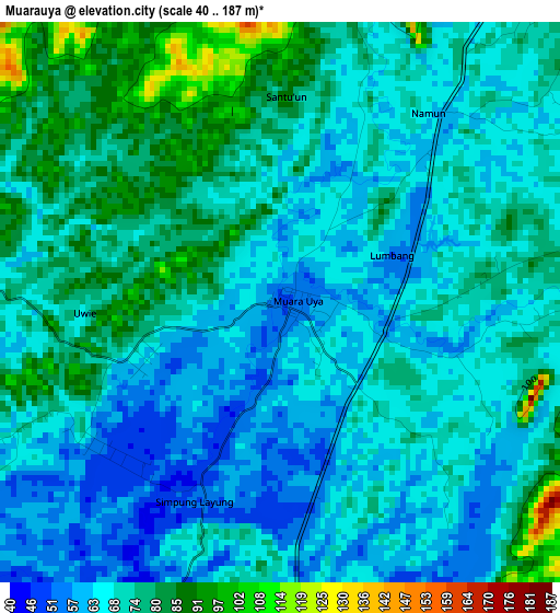
Below is the Elevation map of Muarauya, which displays elevation range with different colors. Scale of the first map is from 40 to 187 m (131 to 614 ft) with average elevation of 70.4 meters (=231 ft) [note 1]
These maps also provides idea of topography and contour of this city, they are displayed at different zoom levels. More info about maps, scale and edge coordinates you can find below images.
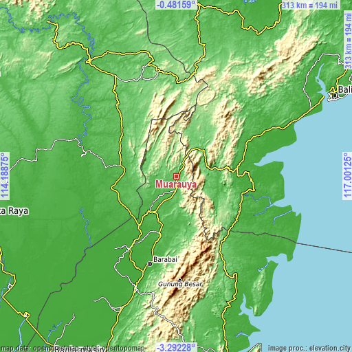
| \ | Map #1 | Topo.Map |
| Scale [m] | 40..187 m | × |
| Scale [ft] | 131..614 ft | × |
| Average | 70.4 m = 231 ft | × |
| Width | 9.77 km = 6.1 mi | 312.5 km = 194.2 mi |
| Height | 9.77 km = 6.1 mi | 312.6 km = 194.2 mi |
| ↑Max Latitude | -1.843578° | -0.48159° |
| Latitude at center | -1.8875° | -1.8875° |
| ↓Min Latitude | -1.931421° | -3.29228° |
| ← Min Longitude | 115.551055° | 114.18875° |
| Longitude center | 115.595° | 115.595° |
| →Max Longitude | 115.638945° | 117.00125° |
Nearby cities:
Cities around Muarauya sort by population:
• Pasararba elevation 14 m
51.6 km,  216°
216°
• Paringin 50 m
51.6 km,  194°
194°
• Tamiang Layang 39 m
51.5 km,  239°
239°
• Juai 28 m
46.5 km,  184°
184°
• Mungkuruyam 36 m
42.2 km, 182°
• Halong 47 m
41.7 km,  171°
171°
• Kelua 32 m
41.4 km,  211°
211°
• Tanta 47 m
41.1 km,  202°
202°
• Tanjung 23 m
37.8 km, 213°
• Batusopang 56 m
36 km,  78°
78°
• Muarakomam 82 m
33.6 km,  46°
46°
• Haruai 31 m
17.2 km, 214°
Multilingual:
 En español:
Muarauya elevación 51 m.
 En France:
Muarauya élévation 51 m.


Sources and notes:
- [note 1] Map square and city borders are not equal. Map elevation data is calculated only from area inside that square.
- [src 1] Elevation data from geonames database provided with same terms of usage.
- [src 2] The elevation map of Muarauya is generated using elevation data from NASA's 3 arcsec (90m) resolution SRTM data.
- [src 3] Base (background) map © OpenStreetMap contributors tiles are generated by Geofabrik and OpenTopoMap.
Copyright & License:
This Muarauya Elevation Map is licensed under CC BY-SA. You may reuse any part from this page, if you give a proper credit by linking to this URL:
 More info on terms of use page.