Muncar elevation
Muncar (East Java), Indonesia elevation is 6 meters and Muncar elevation in feet is 20 ft above sea level [src 1]. Muncar is a populated place (feature code) with elevation that is 185 meters (607 ft) smaller than average city elevation in Indonesia.
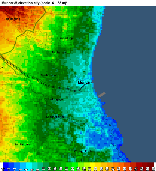
Below is the Elevation map of Muncar, which displays elevation range with different colors. Scale of the first map is from -6 to 58 m (-20 to 190 ft) with average elevation of 19.6 meters (=64 ft) [note 1]
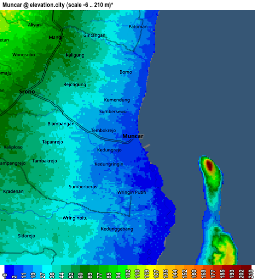
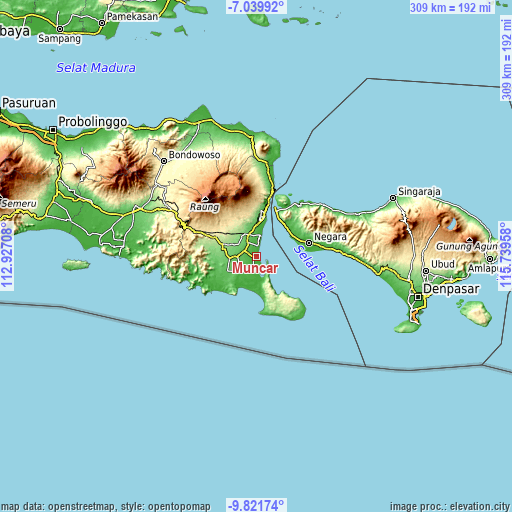
These maps also provides idea of topography and contour of this city, they are displayed at different zoom levels. More info about maps, scale and edge coordinates you can find below images.
| \ | Map #1 | Map #2 | Topo.Map |
| Scale [m] | -6..58 m | -6..210 m | × |
| Scale [ft] | -20..190 ft | -20..689 ft | × |
| Average | 19.6 m = 64 ft | 37.4 m = 123 ft | × |
| Width | 9.67 km = 6 mi | 19.33 km = 12 mi | 309.3 km = 192.2 mi |
| Height | 9.67 km = 6 mi | 19.33 km = 12 mi | 309.3 km = 192.2 mi |
| ↑Max Latitude | -8.389857° | -8.34638° | -7.03992° |
| Latitude at center | -8.43333° | -8.43333° | -8.43333° |
| ↓Min Latitude | -8.476798° | -8.52026° | -9.82174° |
| ← Min Longitude | 114.289385° | 114.245439° | 112.92708° |
| Longitude center | 114.33333° | 114.33333° | 114.33333° |
| →Max Longitude | 114.377275° | 114.421221° | 115.73958° |
Nearby cities:
Cities around Muncar sort by population:
• Banyuwangi elevation 24 m
22.5 km,  6°
6°
• Genteng 172 m
21.5 km,  290°
290°
• Srono 60 m
8.2 km,  296°
296°
• Singojuruh 157 m
17 km,  319°
319°
• Gambiran Satu 143 m
21 km,  282°
282°
• Tirtopuro 107 m
28.2 km, 5°
• Siliragung 28 m
28 km,  240°
240°
• Songgon 348 m
26.2 km,  327°
327°
• Krajan Satu 57 m
25.3 km, 5°
• Olehsari 188 m
24.2 km,  356°
356°
• Purwoharjo 59 m
14.4 km, 238°
• Sumberan 58 m
8.1 km, 297°
Multilingual:
 En español:
Muncar elevación 6 m.
 En France:
Muncar élévation 6 m.


Sources and notes:
- [note 1] Map square and city borders are not equal. Map elevation data is calculated only from area inside that square.
- [src 1] Elevation data from geonames database provided with same terms of usage.
- [src 2] The elevation map of Muncar is generated using elevation data from NASA's 3 arcsec (90m) resolution SRTM data.
- [src 3] Base (background) map © OpenStreetMap contributors tiles are generated by Geofabrik and OpenTopoMap.
Copyright & License:
This Muncar Elevation Map is licensed under CC BY-SA. You may reuse any part from this page, if you give a proper credit by linking to this URL:
 More info on terms of use page.