Ngunut elevation
Ngunut (East Java), Indonesia elevation is 110 meters and Ngunut elevation in feet is 361 ft above sea level [src 1]. Ngunut is a populated place (feature code) with elevation that is 81 meters (266 ft) smaller than average city elevation in Indonesia.
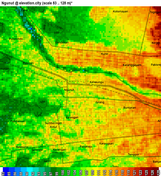
Below is the Elevation map of Ngunut, which displays elevation range with different colors. Scale of the first map is from 83 to 128 m (272 to 420 ft) with average elevation of 108.2 meters (=355 ft) [note 1]
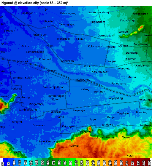
These maps also provides idea of topography and contour of this city, they are displayed at different zoom levels. More info about maps, scale and edge coordinates you can find below images.
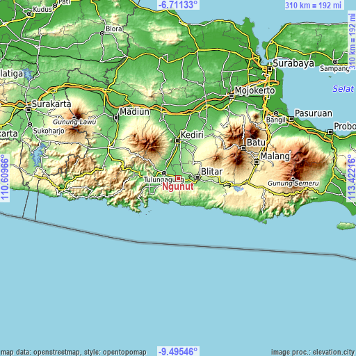
| \ | Map #1 | Map #2 | Topo.Map |
| Scale [m] | 83..128 m | 83..352 m | × |
| Scale [ft] | 272..420 ft | 272..1155 ft | × |
| Average | 108.2 m = 355 ft | 130.7 m = 429 ft | × |
| Width | 9.67 km = 6 mi | 19.35 km = 12 mi | 309.6 km = 192.4 mi |
| Height | 9.67 km = 6 mi | 19.35 km = 12 mi | 309.6 km = 192.4 mi |
| ↑Max Latitude | -8.062291° | -8.018778° | -6.71133° |
| Latitude at center | -8.1058° | -8.1058° | -8.1058° |
| ↓Min Latitude | -8.149304° | -8.192803° | -9.49546° |
| ← Min Longitude | 111.971965° | 111.928019° | 110.60966° |
| Longitude center | 112.01591° | 112.01591° | 112.01591° |
| →Max Longitude | 112.059855° | 112.103801° | 113.42216° |
Nearby cities:
Cities around Ngunut sort by population:
• Blitar elevation 180 m
16.8 km,  87°
87°
• Kedungwaru 90 m
11.8 km,  291°
291°
• Tulungagung 89 m
13.3 km, 289°
• Boyolangu 94 m
13.5 km,  264°
264°
• Bakung 124 m
18.1 km,  159°
159°
• Kalangbret 98 m
17.6 km, 289°
• Pucanglaban 220 m
17.4 km,  180°
180°
• Pakel 89 m
16.7 km,  313°
313°
• Karangrejo 88 m
16.4 km, 314°
• Ngantru 91 m
14.6 km,  316°
316°
• Tamanan 91 m
13 km, 286°
• Kalidawir 109 m
9.6 km,  209°
209°
Multilingual:
 En español:
Ngunut elevación 110 m.
 En France:
Ngunut élévation 110 m.


Sources and notes:
- [note 1] Map square and city borders are not equal. Map elevation data is calculated only from area inside that square.
- [src 1] Elevation data from geonames database provided with same terms of usage.
- [src 2] The elevation map of Ngunut is generated using elevation data from NASA's 3 arcsec (90m) resolution SRTM data.
- [src 3] Base (background) map © OpenStreetMap contributors tiles are generated by Geofabrik and OpenTopoMap.
Copyright & License:
This Ngunut Elevation Map is licensed under CC BY-SA. You may reuse any part from this page, if you give a proper credit by linking to this URL:
 More info on terms of use page.