Palu elevation
Palu (Central Sulawesi), Indonesia elevation is 9 meters and Palu elevation in feet is 30 ft above sea level [src 1]. Palu is a seat of a first-order administrative division (feature code) with elevation that is 182 meters (597 ft) smaller than average city elevation in Indonesia.
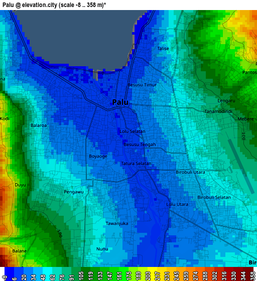
Below is the Elevation map of Palu, which displays elevation range with different colors. Scale of the first map is from -8 to 358 m (-26 to 1175 ft) with average elevation of 65.9 meters (=216 ft) [note 1]
These maps also provides idea of topography and contour of this city, they are displayed at different zoom levels. More info about maps, scale and edge coordinates you can find below images.
| \ | Map #1 | Map #2 | Topo.Map |
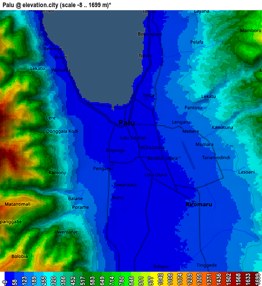
| Scale [m] | -8..358 m | -8..1699 m | × |
| Scale [ft] | -26..1175 ft | -26..5574 ft | × |
| Average | 65.9 m = 216 ft | 301.1 m = 988 ft | × |
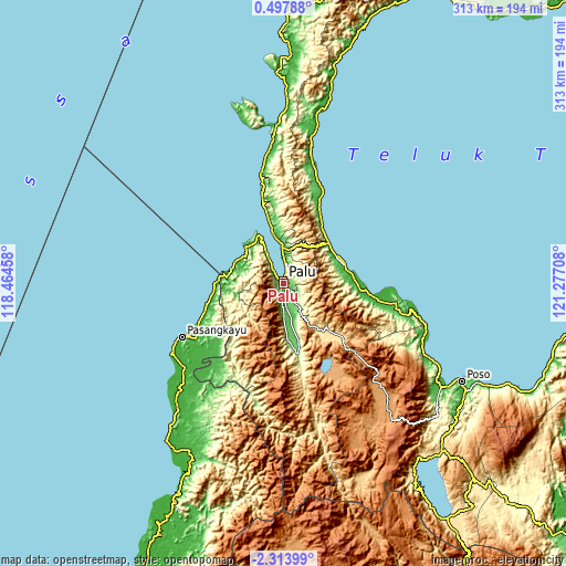
| Width | 9.77 km = 6.1 mi | 19.54 km = 12.1 mi | 312.7 km = 194.3 mi |
| Height | 9.77 km = 6.1 mi | 19.54 km = 12.1 mi | 312.7 km = 194.3 mi |
| ↑Max Latitude | -0.86439° | -0.820449° | 0.49788° |
| Latitude at center | -0.90833° | -0.90833° | -0.90833° |
| ↓Min Latitude | -0.95227° | -0.996208° | -2.31399° |
| ← Min Longitude | 119.826885° | 119.782939° | 118.46458° |
| Longitude center | 119.87083° | 119.87083° | 119.87083° |
| →Max Longitude | 119.914775° | 119.958721° | 121.27708° |
Nearby cities:
Cities around Palu sort by population:
• Poso elevation 10 m
112 km,  118°
118°
• Masamba 42 m
189.9 km,  164°
164°
• Kalumpang 87 m
179.7 km,  193°
193°
• Pendolo 521 m
158.1 km,  145°
145°
• Babana 7 m
150 km,  209°
209°
• Tobadak 21 m
143.6 km,  203°
203°
• Tentena 522 m
127.9 km,  137°
137°
• Tagolu 15 m
116.4 km, 120°
• Kasiguncu 7 m
104.2 km, 123°
• Parigi 12 m
35.5 km,  73°
73°
• Donggala 13 m
30 km,  331°
331°
• Sigi Biromaru 69 m
7 km,  131°
131°
Multilingual:
 En español:
Palu elevación 9 m.
 En France:
Palu élévation 9 m.


Sources and notes:
- [note 1] Map square and city borders are not equal. Map elevation data is calculated only from area inside that square.
- [src 1] Elevation data from geonames database provided with same terms of usage.
- [src 2] The elevation map of Palu is generated using elevation data from NASA's 3 arcsec (90m) resolution SRTM data.
- [src 3] Base (background) map © OpenStreetMap contributors tiles are generated by Geofabrik and OpenTopoMap.
Copyright & License:
This Palu Elevation Map is licensed under CC BY-SA. You may reuse any part from this page, if you give a proper credit by linking to this URL:
 More info on terms of use page.