Pandeglang elevation
Pandeglang (Banten), Indonesia elevation is 253 meters and Pandeglang elevation in feet is 830 ft above sea level [src 1]. Pandeglang is a seat of a second-order administrative division (feature code) with elevation that is 62 meters (203 ft) bigger than average city elevation in Indonesia.
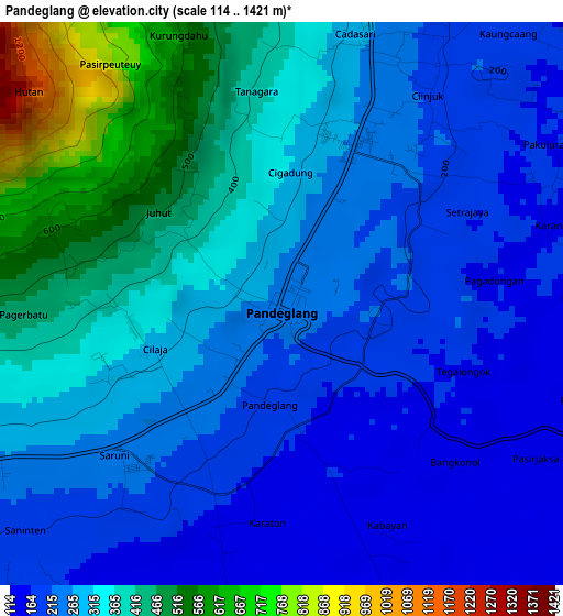
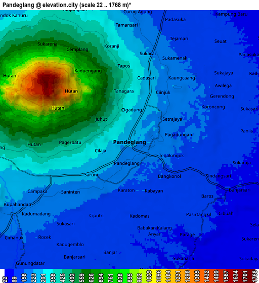
Below is the Elevation map of Pandeglang, which displays elevation range with different colors. Scale of the first map is from 114 to 1421 m (374 to 4662 ft) with average elevation of 300 meters (=984 ft) [note 1]
These maps also provides idea of topography and contour of this city, they are displayed at different zoom levels. More info about maps, scale and edge coordinates you can find below images.
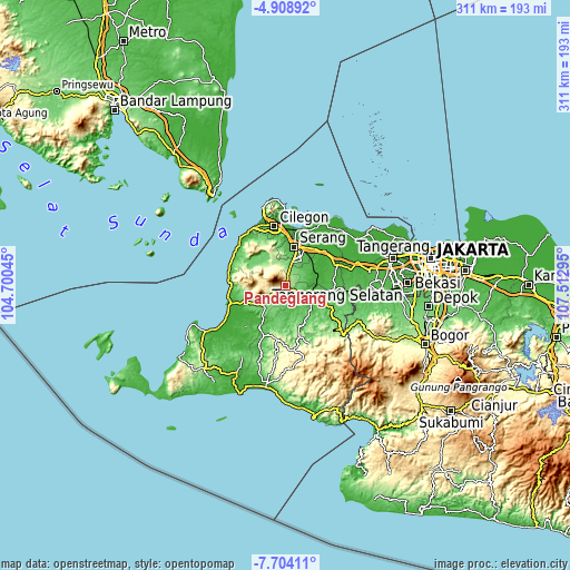
| \ | Map #1 | Map #2 | Topo.Map |
| Scale [m] | 114..1421 m | 22..1768 m | × |
| Scale [ft] | 374..4662 ft | 72..5801 ft | × |
| Average | 300 m = 984 ft | 282.1 m = 926 ft | × |
| Width | 9.71 km = 6 mi | 19.43 km = 12.1 mi | 310.8 km = 193.1 mi |
| Height | 9.71 km = 6 mi | 19.43 km = 12.1 mi | 310.8 km = 193.1 mi |
| ↑Max Latitude | -6.264719° | -6.221034° | -4.90892° |
| Latitude at center | -6.3084° | -6.3084° | -6.3084° |
| ↓Min Latitude | -6.352077° | -6.395751° | -7.70411° |
| ← Min Longitude | 106.062755° | 106.018809° | 104.70045° |
| Longitude center | 106.1067° | 106.1067° | 106.1067° |
| →Max Longitude | 106.150645° | 106.194591° | 107.51295° |
Nearby cities:
Cities around Pandeglang sort by population:
• Serang elevation 29 m
22.1 km,  13°
13°
• Rangkasbitung 27 m
16.7 km,  109°
109°
• Menes 115 m
22.1 km,  250°
250°
• Padarincang 105 m
20.1 km,  301°
301°
• Saketi 137 m
16.3 km,  230°
230°
• Mandalawangi 429 m
13.1 km,  269°
269°
• Ciomas 296 m
12.3 km,  325°
325°
• Pabuaran 201 m
12.2 km,  341°
341°
• Batubantar 203 m
8.3 km,  236°
236°
• Kadugedong 118 m
6.2 km,  186°
186°
• Kaburon 220 m
3.2 km,  43°
43°
• Gardutanjak 221 m
0.8 km, 227°
Multilingual:
 En español:
Pandeglang elevación 253 m.
 En France:
Pandeglang élévation 253 m.
 Auf Deutsch:
Pandeglang höhe über dem Meeresspiegel ist 253 m.

Sources and notes:
- [note 1] Map square and city borders are not equal. Map elevation data is calculated only from area inside that square.
- [src 1] Elevation data from geonames database provided with same terms of usage.
- [src 2] The elevation map of Pandeglang is generated using elevation data from NASA's 3 arcsec (90m) resolution SRTM data.
- [src 3] Base (background) map © OpenStreetMap contributors tiles are generated by Geofabrik and OpenTopoMap.
Copyright & License:
This Pandeglang Elevation Map is licensed under CC BY-SA. You may reuse any part from this page, if you give a proper credit by linking to this URL:
 More info on terms of use page.