Panti elevation
Panti (West Sumatra), Indonesia elevation is 283 meters and Panti elevation in feet is 928 ft above sea level [src 1]. Panti is a seat of a third-order administrative division (feature code) with elevation that is 92 meters (302 ft) bigger than average city elevation in Indonesia.
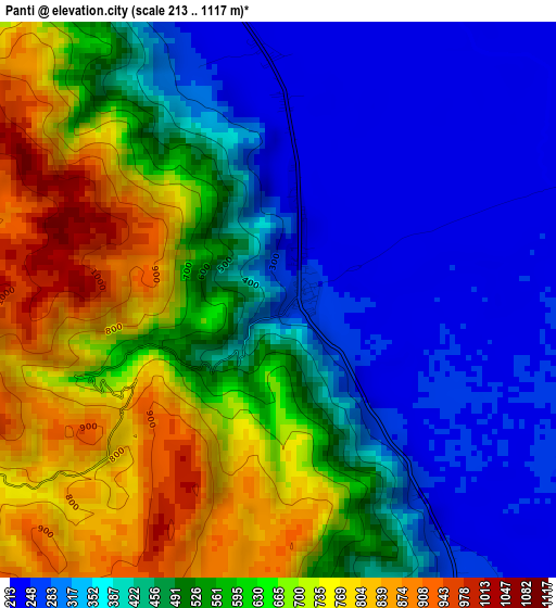
Below is the Elevation map of Panti, which displays elevation range with different colors. Scale of the first map is from 213 to 1117 m (699 to 3665 ft) with average elevation of 503.9 meters (=1653 ft) [note 1]
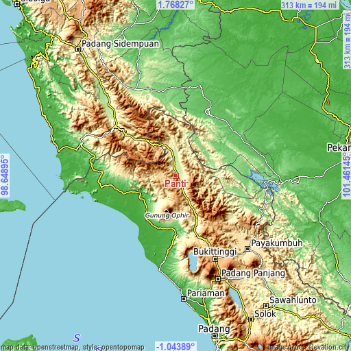
These maps also provides idea of topography and contour of this city, they are displayed at different zoom levels. More info about maps, scale and edge coordinates you can find below images.
| \ | Map #1 | Topo.Map |
| Scale [m] | 213..1117 m | × |
| Scale [ft] | 699..3665 ft | × |
| Average | 503.9 m = 1653 ft | × |
| Width | 9.77 km = 6.1 mi | 312.7 km = 194.3 mi |
| Height | 9.77 km = 6.1 mi | 312.7 km = 194.3 mi |
| ↑Max Latitude | 0.406244° | 1.76827° |
| Latitude at center | 0.3623° | 0.3623° |
| ↓Min Latitude | 0.318355° | -1.04389° |
| ← Min Longitude | 100.011255° | 98.64895° |
| Longitude center | 100.0552° | 100.0552° |
| →Max Longitude | 100.099145° | 101.46145° |
Nearby cities:
Cities around Panti sort by population:
• Pasarujungbatu elevation 103 m
75.8 km,  350°
350°
• Matur 1037 m
75.8 km,  160°
160°
• Palembaian 710 m
63.8 km, 161°
• Pasir Pengaraian 58 m
61.9 km,  25°
25°
• Ujung Gading 32 m
56.2 km,  259°
259°
• Kotanopan 438 m
51.3 km,  311°
311°
• Bonjol 297 m
46.4 km, 155°
• Rokan 97 m
45.5 km,  59°
59°
• Simpang Empat 64 m
39.2 km,  221°
221°
• Lubuk Sikaping 453 m
27.2 km,  153°
153°
• Muara Sipongi 253 m
23.5 km, 348°
• Talu 499 m
16.8 km,  209°
209°
Multilingual:
 En español:
Panti elevación 283 m.
 En France:
Panti élévation 283 m.


Sources and notes:
- [note 1] Map square and city borders are not equal. Map elevation data is calculated only from area inside that square.
- [src 1] Elevation data from geonames database provided with same terms of usage.
- [src 2] The elevation map of Panti is generated using elevation data from NASA's 3 arcsec (90m) resolution SRTM data.
- [src 3] Base (background) map © OpenStreetMap contributors tiles are generated by Geofabrik and OpenTopoMap.
Copyright & License:
This Panti Elevation Map is licensed under CC BY-SA. You may reuse any part from this page, if you give a proper credit by linking to this URL:
 More info on terms of use page.