Parepare elevation
Parepare (South Sulawesi), Indonesia elevation is 22 meters and Parepare elevation in feet is 72 ft above sea level [src 1]. Parepare is a populated place (feature code) with elevation that is 169 meters (554 ft) smaller than average city elevation in Indonesia.
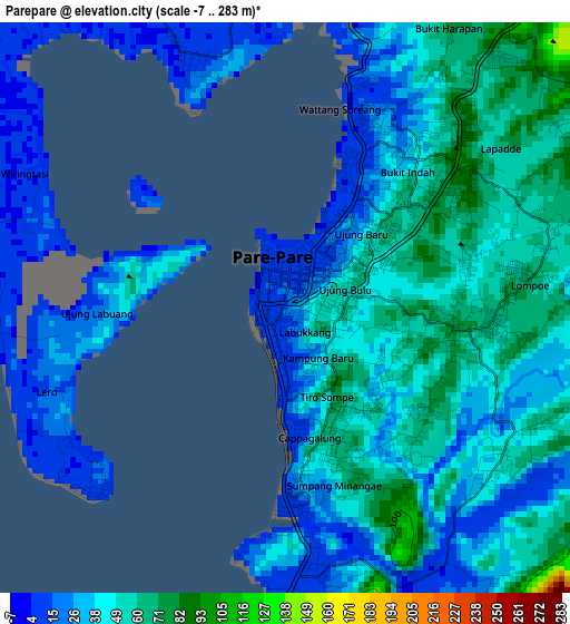
Below is the Elevation map of Parepare, which displays elevation range with different colors. Scale of the first map is from -7 to 283 m (-23 to 928 ft) with average elevation of 41 meters (=135 ft) [note 1]
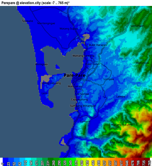
These maps also provides idea of topography and contour of this city, they are displayed at different zoom levels. More info about maps, scale and edge coordinates you can find below images.
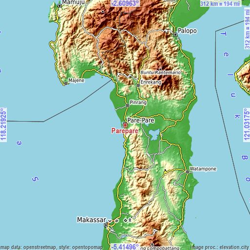
| \ | Map #1 | Map #2 | Topo.Map |
| Scale [m] | -7..283 m | -7..765 m | × |
| Scale [ft] | -23..928 ft | -23..2510 ft | × |
| Average | 41 m = 135 ft | 133.7 m = 439 ft | × |
| Width | 9.75 km = 6.1 mi | 19.5 km = 12.1 mi | 311.9 km = 193.8 mi |
| Height | 9.75 km = 6.1 mi | 19.5 km = 12.1 mi | 312 km = 193.9 mi |
| ↑Max Latitude | -3.969661° | -3.92582° | -2.60963° |
| Latitude at center | -4.0135° | -4.0135° | -4.0135° |
| ↓Min Latitude | -4.057336° | -4.10117° | -5.41496° |
| ← Min Longitude | 119.581555° | 119.537609° | 118.21925° |
| Longitude center | 119.6255° | 119.6255° | 119.6255° |
| →Max Longitude | 119.669445° | 119.713391° | 121.03175° |
Nearby cities:
Cities around Parepare sort by population:
• Lampa elevation 10 m
40.2 km,  345°
345°
• Teppo 25 m
34.5 km,  8°
8°
• Cempa Pasar 16 m
29.8 km, 351°
• Rappang 37 m
28.4 km,  48°
48°
• Baranti 29 m
26.1 km,  42°
42°
• Pinrang 19 m
25.5 km, 6°
• Langnga 9 m
21.9 km,  328°
328°
• Sidenreng 22 m
21.5 km,  63°
63°
• Amparita 23 m
20.8 km,  83°
83°
• Uluale 32 m
17.7 km, 48°
• Majennang 8 m
4.9 km,  338°
338°
• Harapankarya 31 m
3.4 km, 37°
Multilingual:
 En español:
Parepare elevación 22 m.
 En France:
Parepare élévation 22 m.


Sources and notes:
- [note 1] Map square and city borders are not equal. Map elevation data is calculated only from area inside that square.
- [src 1] Elevation data from geonames database provided with same terms of usage.
- [src 2] The elevation map of Parepare is generated using elevation data from NASA's 3 arcsec (90m) resolution SRTM data.
- [src 3] Base (background) map © OpenStreetMap contributors tiles are generated by Geofabrik and OpenTopoMap.
Copyright & License:
This Parepare Elevation Map is licensed under CC BY-SA. You may reuse any part from this page, if you give a proper credit by linking to this URL:
 More info on terms of use page.