Pariaman elevation
Pariaman (West Sumatra), Indonesia elevation is 4 meters and Pariaman elevation in feet is 13 ft above sea level [src 1]. Pariaman is a seat of a third-order administrative division (feature code) with elevation that is 187 meters (614 ft) smaller than average city elevation in Indonesia.
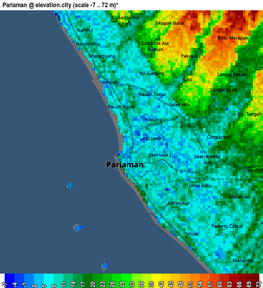
Below is the Elevation map of Pariaman, which displays elevation range with different colors. Scale of the first map is from -7 to 72 m (-23 to 236 ft) with average elevation of 18.4 meters (=60 ft) [note 1]
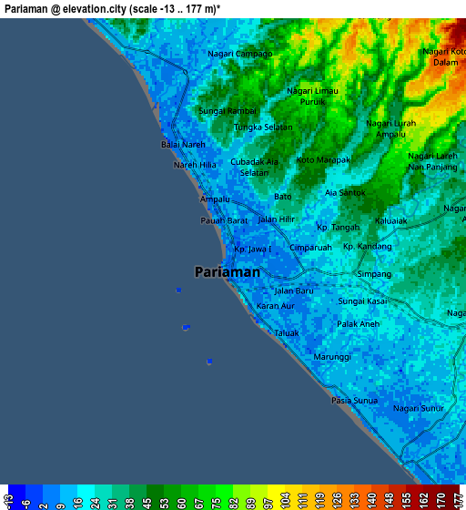
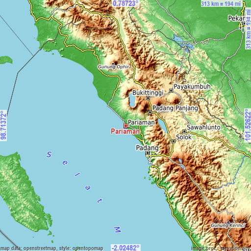
These maps also provides idea of topography and contour of this city, they are displayed at different zoom levels. More info about maps, scale and edge coordinates you can find below images.
| \ | Map #1 | Map #2 | Topo.Map |
| Scale [m] | -7..72 m | -13..177 m | × |
| Scale [ft] | -23..236 ft | -43..581 ft | × |
| Average | 18.4 m = 60 ft | 35.8 m = 117 ft | × |
| Width | 9.77 km = 6.1 mi | 19.54 km = 12.1 mi | 312.7 km = 194.3 mi |
| Height | 9.77 km = 6.1 mi | 19.54 km = 12.1 mi | 312.7 km = 194.3 mi |
| ↑Max Latitude | -0.575037° | -0.531094° | 0.78723° |
| Latitude at center | -0.61898° | -0.61898° | -0.61898° |
| ↓Min Latitude | -0.662923° | -0.706865° | -2.02482° |
| ← Min Longitude | 100.076025° | 100.032079° | 98.71372° |
| Longitude center | 100.11997° | 100.11997° | 100.11997° |
| →Max Longitude | 100.163915° | 100.207861° | 101.52622° |
Nearby cities:
Cities around Pariaman sort by population:
• Kotatua elevation 1007 m
40.7 km,  41°
41°
• Tabing 3 m
37.5 km,  138°
138°
• Maninjau 473 m
37.3 km,  18°
18°
• Lubuk Basung 127 m
33.2 km,  349°
349°
• Tiku 5 m
33.1 km,  318°
318°
• Lubukalung 36 m
23.2 km,  107°
107°
• Lubukalung 28 m
19.9 km, 112°
• Parit Malintang 80 m
17.7 km,  90°
90°
• Sungailimau 33 m
13.1 km,  330°
330°
• Sungaisarik 44 m
12.7 km,  66°
66°
• Pauhambar 26 m
11.1 km, 111°
• Kampungladang 96 m
10.2 km,  33°
33°
Multilingual:
 En español:
Pariaman elevación 4 m.
 En France:
Pariaman élévation 4 m.


Sources and notes:
- [note 1] Map square and city borders are not equal. Map elevation data is calculated only from area inside that square.
- [src 1] Elevation data from geonames database provided with same terms of usage.
- [src 2] The elevation map of Pariaman is generated using elevation data from NASA's 3 arcsec (90m) resolution SRTM data.
- [src 3] Base (background) map © OpenStreetMap contributors tiles are generated by Geofabrik and OpenTopoMap.
Copyright & License:
This Pariaman Elevation Map is licensed under CC BY-SA. You may reuse any part from this page, if you give a proper credit by linking to this URL:
 More info on terms of use page.