Payakumbuh elevation
Payakumbuh (West Sumatra), Indonesia elevation is 517 meters and Payakumbuh elevation in feet is 1696 ft above sea level [src 1]. Payakumbuh is a seat of a second-order administrative division (feature code) with elevation that is 326 meters (1070 ft) bigger than average city elevation in Indonesia.
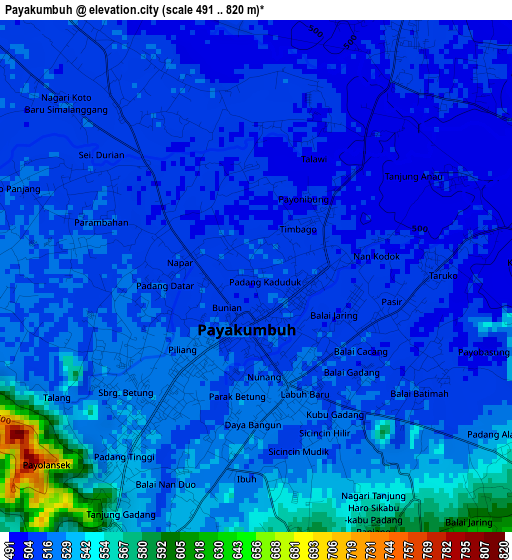
Below is the Elevation map of Payakumbuh, which displays elevation range with different colors. Scale of the first map is from 491 to 820 m (1611 to 2690 ft) with average elevation of 520.8 meters (=1709 ft) [note 1]
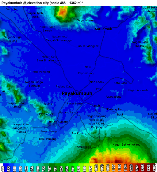
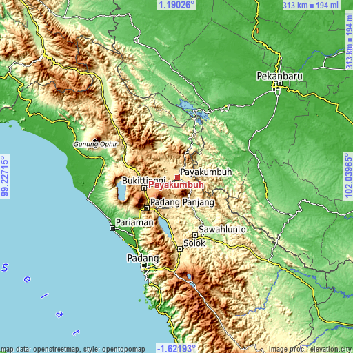
These maps also provides idea of topography and contour of this city, they are displayed at different zoom levels. More info about maps, scale and edge coordinates you can find below images.
| \ | Map #1 | Map #2 | Topo.Map |
| Scale [m] | 491..820 m | 488..1362 m | × |
| Scale [ft] | 1611..2690 ft | 1601..4469 ft | × |
| Average | 520.8 m = 1709 ft | 586.2 m = 1923 ft | × |
| Width | 9.77 km = 6.1 mi | 19.54 km = 12.1 mi | 312.7 km = 194.3 mi |
| Height | 9.77 km = 6.1 mi | 19.54 km = 12.1 mi | 312.7 km = 194.3 mi |
| ↑Max Latitude | -0.171955° | -0.12801° | 1.19026° |
| Latitude at center | -0.2159° | -0.2159° | -0.2159° |
| ↓Min Latitude | -0.259845° | -0.30379° | -1.62193° |
| ← Min Longitude | 100.589455° | 100.545509° | 99.22715° |
| Longitude center | 100.6334° | 100.6334° | 100.6334° |
| →Max Longitude | 100.677345° | 100.721291° | 102.03965° |
Nearby cities:
Cities around Payakumbuh sort by population:
• Bukittinggi elevation 927 m
31 km,  250°
250°
• Rambatan 583 m
32.2 km,  197°
197°
• Simabur 708 m
30 km, 202°
• Saruaso 342 m
29.7 km,  179°
179°
• Batusangkar 413 m
27.3 km,  185°
185°
• Sungayang 565 m
21.7 km, 190°
• Baso 890 m
21.2 km, 250°
• Salimpaung 957 m
17.8 km,  211°
211°
• Tanjunggadang 611 m
15 km,  129°
129°
• Guguk 528 m
12.4 km,  313°
313°
• Tanjungpati 501 m
8.1 km,  40°
40°
• Sarilamak 501 m
8 km,  25°
25°
Multilingual:
 En español:
Payakumbuh elevación 517 m.
 En France:
Payakumbuh élévation 517 m.
 Auf Deutsch:
Payakumbuh höhe über dem Meeresspiegel ist 517 m.

Sources and notes:
- [note 1] Map square and city borders are not equal. Map elevation data is calculated only from area inside that square.
- [src 1] Elevation data from geonames database provided with same terms of usage.
- [src 2] The elevation map of Payakumbuh is generated using elevation data from NASA's 3 arcsec (90m) resolution SRTM data.
- [src 3] Base (background) map © OpenStreetMap contributors tiles are generated by Geofabrik and OpenTopoMap.
Copyright & License:
This Payakumbuh Elevation Map is licensed under CC BY-SA. You may reuse any part from this page, if you give a proper credit by linking to this URL:
 More info on terms of use page.