Prabumulih elevation
Prabumulih (South Sumatra), Indonesia elevation is 51 meters and Prabumulih elevation in feet is 167 ft above sea level [src 1]. Prabumulih is a seat of a third-order administrative division (feature code) with elevation that is 140 meters (459 ft) smaller than average city elevation in Indonesia.
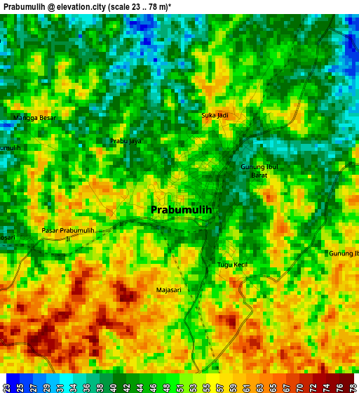
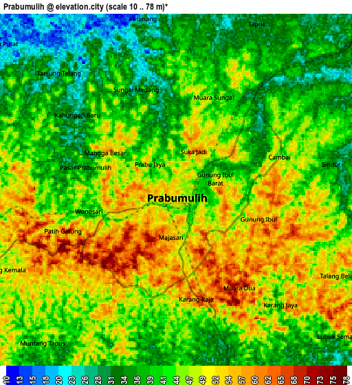
Below is the Elevation map of Prabumulih, which displays elevation range with different colors. Scale of the first map is from 23 to 78 m (75 to 256 ft) with average elevation of 49.6 meters (=163 ft) [note 1]
These maps also provides idea of topography and contour of this city, they are displayed at different zoom levels. More info about maps, scale and edge coordinates you can find below images.
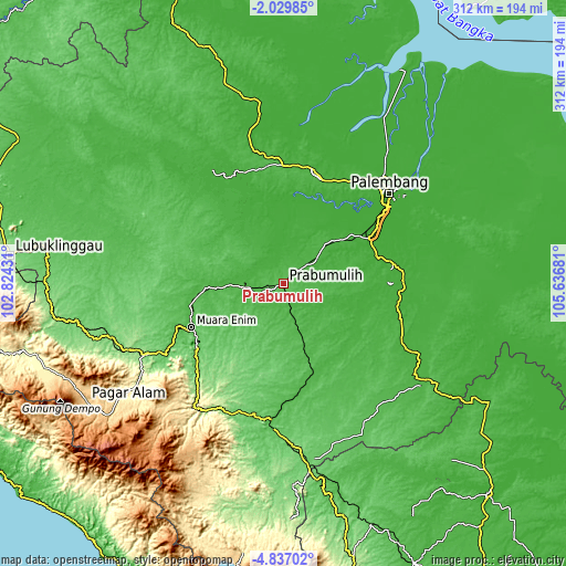
| \ | Map #1 | Map #2 | Topo.Map |
| Scale [m] | 23..78 m | 10..78 m | × |
| Scale [ft] | 75..256 ft | 33..256 ft | × |
| Average | 49.6 m = 163 ft | 43.5 m = 143 ft | × |
| Width | 9.75 km = 6.1 mi | 19.51 km = 12.1 mi | 312.1 km = 193.9 mi |
| Height | 9.75 km = 6.1 mi | 19.51 km = 12.1 mi | 312.2 km = 194 mi |
| ↑Max Latitude | -3.390603° | -3.346733° | -2.02985° |
| Latitude at center | -3.43447° | -3.43447° | -3.43447° |
| ↓Min Latitude | -3.478335° | -3.522199° | -4.83702° |
| ← Min Longitude | 104.186615° | 104.142669° | 102.82431° |
| Longitude center | 104.23056° | 104.23056° | 104.23056° |
| →Max Longitude | 104.274505° | 104.318451° | 105.63681° |
Nearby cities:
Cities around Prabumulih sort by population:
• Tanjung Lubuk elevation 19 m
59.5 km,  99°
99°
• Cempaka 32 m
58.7 km,  124°
124°
• Muara Enim 41 m
56.3 km,  244°
244°
• Indralaya 8 m
53.4 km,  67°
67°
• Peninjawan 34 m
51.2 km,  160°
160°
• Talang Ubi 30 m
48.7 km,  292°
292°
• Suban Jeriji 87 m
45.6 km,  220°
220°
• Muarakuang 21 m
45.4 km, 124°
• Gunungmegang Dalam 27 m
40.1 km,  267°
267°
• Sungairotan 13 m
37.3 km,  8°
8°
• Gunungmenang 14 m
35.8 km,  322°
322°
• Glumbang 25 m
31.6 km,  46°
46°
Multilingual:
 En español:
Prabumulih elevación 51 m.
 En France:
Prabumulih élévation 51 m.
 Auf Deutsch:
Prabumulih höhe über dem Meeresspiegel ist 51 m.

Sources and notes:
- [note 1] Map square and city borders are not equal. Map elevation data is calculated only from area inside that square.
- [src 1] Elevation data from geonames database provided with same terms of usage.
- [src 2] The elevation map of Prabumulih is generated using elevation data from NASA's 3 arcsec (90m) resolution SRTM data.
- [src 3] Base (background) map © OpenStreetMap contributors tiles are generated by Geofabrik and OpenTopoMap.
Copyright & License:
This Prabumulih Elevation Map is licensed under CC BY-SA. You may reuse any part from this page, if you give a proper credit by linking to this URL:
 More info on terms of use page.