Probolinggo elevation
Probolinggo (East Java), Indonesia elevation is 15 meters and Probolinggo elevation in feet is 49 ft above sea level [src 1]. Probolinggo is a populated place (feature code) with elevation that is 176 meters (577 ft) smaller than average city elevation in Indonesia.
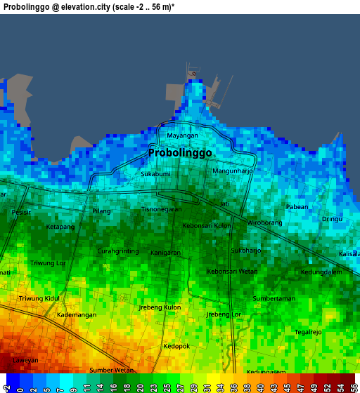
Below is the Elevation map of Probolinggo, which displays elevation range with different colors. Scale of the first map is from -2 to 56 m (-7 to 184 ft) with average elevation of 19.2 meters (=63 ft) [note 1]
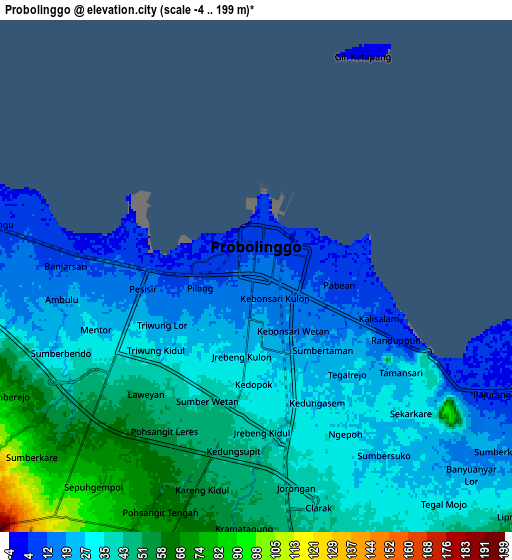
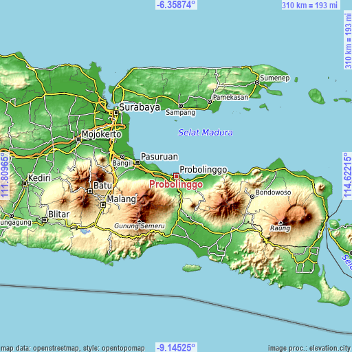
These maps also provides idea of topography and contour of this city, they are displayed at different zoom levels. More info about maps, scale and edge coordinates you can find below images.
| \ | Map #1 | Map #2 | Topo.Map |
| Scale [m] | -2..56 m | -4..199 m | × |
| Scale [ft] | -7..184 ft | -13..653 ft | × |
| Average | 19.2 m = 63 ft | 34.4 m = 113 ft | × |
| Width | 9.68 km = 6 mi | 19.37 km = 12 mi | 309.8 km = 192.5 mi |
| Height | 9.68 km = 6 mi | 19.37 km = 12 mi | 309.9 km = 192.6 mi |
| ↑Max Latitude | -7.710754° | -7.667204° | -6.35874° |
| Latitude at center | -7.7543° | -7.7543° | -7.7543° |
| ↓Min Latitude | -7.797841° | -7.841378° | -9.14525° |
| ← Min Longitude | 113.171955° | 113.128009° | 111.80965° |
| Longitude center | 113.2159° | 113.2159° | 113.2159° |
| →Max Longitude | 113.259845° | 113.303791° | 114.62215° |
Nearby cities:
Cities around Probolinggo sort by population:
• Pasuruan elevation 9 m
36.1 km,  289°
289°
• Lumajang 56 m
42.2 km,  178°
178°
• Bangil 2 m
47 km, 291°
• Kraksaan 1 m
19.9 km,  91°
91°
• Rowokangkung 20 m
50.5 km,  165°
165°
• Tekung 25 m
47.1 km, 171°
• Sumberbaru 46 m
44.7 km,  154°
154°
• Jatiroto 31 m
44 km,  158°
158°
• Senduro 441 m
40.2 km,  200°
200°
• Randuagung 98 m
36.6 km, 164°
• Pule 511 m
33.7 km,  194°
194°
• Darungan Lor 114 m
32.3 km, 176°
Multilingual:
 En español:
Probolinggo elevación 15 m.
 En France:
Probolinggo élévation 15 m.
 Auf Deutsch:
Probolinggo höhe über dem Meeresspiegel ist 15 m.

Sources and notes:
- [note 1] Map square and city borders are not equal. Map elevation data is calculated only from area inside that square.
- [src 1] Elevation data from geonames database provided with same terms of usage.
- [src 2] The elevation map of Probolinggo is generated using elevation data from NASA's 3 arcsec (90m) resolution SRTM data.
- [src 3] Base (background) map © OpenStreetMap contributors tiles are generated by Geofabrik and OpenTopoMap.
Copyright & License:
This Probolinggo Elevation Map is licensed under CC BY-SA. You may reuse any part from this page, if you give a proper credit by linking to this URL:
 More info on terms of use page.