Purwodadi elevation
Purwodadi (Central Java), Indonesia elevation is 29 meters and Purwodadi elevation in feet is 95 ft above sea level [src 1]. Purwodadi is a seat of a second-order administrative division (feature code) with elevation that is 162 meters (531 ft) smaller than average city elevation in Indonesia.
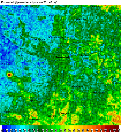
Below is the Elevation map of Purwodadi, which displays elevation range with different colors. Scale of the first map is from 20 to 47 m (66 to 154 ft) with average elevation of 28.7 meters (=94 ft) [note 1]
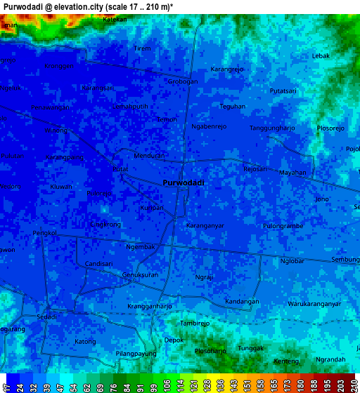
These maps also provides idea of topography and contour of this city, they are displayed at different zoom levels. More info about maps, scale and edge coordinates you can find below images.
| \ | Map #1 | Map #2 | Topo.Map |
| Scale [m] | 20..47 m | 17..210 m | × |
| Scale [ft] | 66..154 ft | 56..689 ft | × |
| Average | 28.7 m = 94 ft | 37.6 m = 123 ft | × |
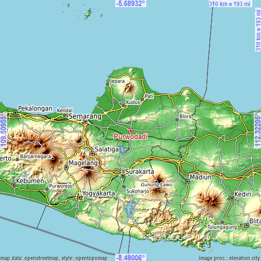
| Width | 9.7 km = 6 mi | 19.4 km = 12.1 mi | 310.3 km = 192.8 mi |
| Height | 9.7 km = 6 mi | 19.4 km = 12.1 mi | 310.3 km = 192.8 mi |
| ↑Max Latitude | -7.043188° | -6.999573° | -5.68932° |
| Latitude at center | -7.0868° | -7.0868° | -7.0868° |
| ↓Min Latitude | -7.130408° | -7.174011° | -8.48006° |
| ← Min Longitude | 110.871855° | 110.827909° | 109.50955° |
| Longitude center | 110.9158° | 110.9158° | 110.9158° |
| →Max Longitude | 110.959745° | 111.003691° | 112.32205° |
Nearby cities:
Cities around Purwodadi sort by population:
• Pati elevation 13 m
39.2 km,  20°
20°
• Kudus 27 m
32.4 km,  345°
345°
• Sragen 90 m
39.5 km,  162°
162°
• Baekrajan 68 m
36.2 km, 349°
• Gebog 127 m
39.9 km, 348°
• Jekulo 15 m
31.3 km,  2°
2°
• Mranggen 20 m
44.6 km,  278°
278°
• Demak 9 m
37.5 km,  305°
305°
• Welahan 4 m
38.7 km,  325°
325°
• Japah 98 m
44.3 km,  68°
68°
• Tlogowungu 66 m
43.6 km,  14°
14°
• Balong 59 m
39.5 km,  45°
45°
Multilingual:
 En español:
Purwodadi elevación 29 m.
 En France:
Purwodadi élévation 29 m.
 Auf Deutsch:
Purwodadi höhe über dem Meeresspiegel ist 29 m.

Sources and notes:
- [note 1] Map square and city borders are not equal. Map elevation data is calculated only from area inside that square.
- [src 1] Elevation data from geonames database provided with same terms of usage.
- [src 2] The elevation map of Purwodadi is generated using elevation data from NASA's 3 arcsec (90m) resolution SRTM data.
- [src 3] Base (background) map © OpenStreetMap contributors tiles are generated by Geofabrik and OpenTopoMap.
Copyright & License:
This Purwodadi Elevation Map is licensed under CC BY-SA. You may reuse any part from this page, if you give a proper credit by linking to this URL:
 More info on terms of use page.