Ruteng elevation
Ruteng (East Nusa Tenggara), Indonesia elevation is 1173 meters and Ruteng elevation in feet is 3848 ft above sea level [src 1]. Ruteng is a seat of a second-order administrative division (feature code) with elevation that is 982 meters (3222 ft) bigger than average city elevation in Indonesia.
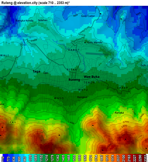
Below is the Elevation map of Ruteng, which displays elevation range with different colors. Scale of the first map is from 710 to 2353 m (2329 to 7720 ft) with average elevation of 1299.5 meters (=4263 ft) [note 1]
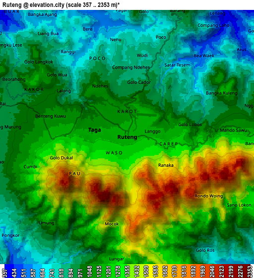
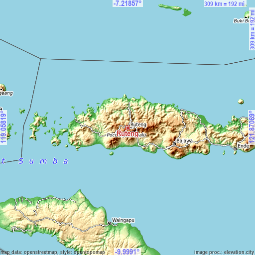
These maps also provides idea of topography and contour of this city, they are displayed at different zoom levels. More info about maps, scale and edge coordinates you can find below images.
| \ | Map #1 | Map #2 | Topo.Map |
| Scale [m] | 710..2353 m | 357..2353 m | × |
| Scale [ft] | 2329..7720 ft | 1171..7720 ft | × |
| Average | 1299.5 m = 4263 ft | 1100.9 m = 3612 ft | × |
| Width | 9.66 km = 6 mi | 19.32 km = 12 mi | 309.2 km = 192.1 mi |
| Height | 9.66 km = 6 mi | 19.32 km = 12 mi | 309.2 km = 192.1 mi |
| ↑Max Latitude | -8.567938° | -8.52448° | -7.21857° |
| Latitude at center | -8.61139° | -8.61139° | -8.61139° |
| ↓Min Latitude | -8.654837° | -8.69828° | -9.9991° |
| ← Min Longitude | 120.420495° | 120.376549° | 119.05819° |
| Longitude center | 120.46444° | 120.46444° | 120.46444° |
| →Max Longitude | 120.508385° | 120.552331° | 121.87069° |
Nearby cities:
Cities around Ruteng sort by population:
• Labuan Bajo elevation 63 m
64.7 km,  281°
281°
• Soa 506 m
63.6 km,  98°
98°
• Bajawa 1206 m
59.3 km,  108°
108°
• Aimere 15 m
50.3 km,  120°
120°
• Werang 348 m
50.1 km,  265°
265°
• Waelengga 23 m
44.6 km, 122°
• Pota 10 m
44.3 km,  47°
47°
• Toroloji 16 m
43 km,  310°
310°
• Senggapi 14 m
34.8 km,  359°
359°
• Borong 32 m
27.5 km,  144°
144°
• Iteng 47 m
22.8 km,  191°
191°
• Bentengjawa 872 m
20.9 km,  34°
34°
Multilingual:
 En español:
Ruteng elevación 1173 m.
 En France:
Ruteng élévation 1173 m.


Sources and notes:
- [note 1] Map square and city borders are not equal. Map elevation data is calculated only from area inside that square.
- [src 1] Elevation data from geonames database provided with same terms of usage.
- [src 2] The elevation map of Ruteng is generated using elevation data from NASA's 3 arcsec (90m) resolution SRTM data.
- [src 3] Base (background) map © OpenStreetMap contributors tiles are generated by Geofabrik and OpenTopoMap.
Copyright & License:
This Ruteng Elevation Map is licensed under CC BY-SA. You may reuse any part from this page, if you give a proper credit by linking to this URL:
 More info on terms of use page.