Salatiga elevation
Salatiga (Central Java), Indonesia elevation is 571 meters and Salatiga elevation in feet is 1873 ft above sea level [src 1]. Salatiga is a populated place (feature code) with elevation that is 380 meters (1247 ft) bigger than average city elevation in Indonesia.
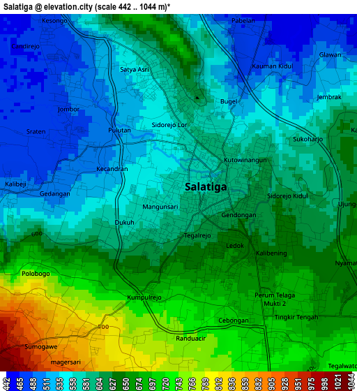
Below is the Elevation map of Salatiga, which displays elevation range with different colors. Scale of the first map is from 442 to 1044 m (1450 to 3425 ft) with average elevation of 611.2 meters (=2005 ft) [note 1]
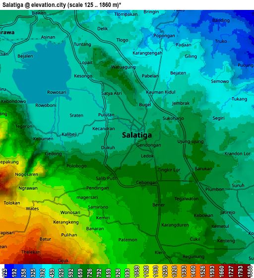
These maps also provides idea of topography and contour of this city, they are displayed at different zoom levels. More info about maps, scale and edge coordinates you can find below images.
| \ | Map #1 | Map #2 | Topo.Map |
| Scale [m] | 442..1044 m | 125..1860 m | × |
| Scale [ft] | 1450..3425 ft | 410..6102 ft | × |
| Average | 611.2 m = 2005 ft | 659.8 m = 2165 ft | × |
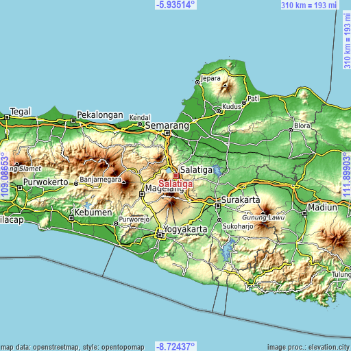
| Width | 9.69 km = 6 mi | 19.39 km = 12 mi | 310.1 km = 192.7 mi |
| Height | 9.69 km = 6 mi | 19.39 km = 12 mi | 310.2 km = 192.7 mi |
| ↑Max Latitude | -7.288352° | -7.24476° | -5.93514° |
| Latitude at center | -7.33194° | -7.33194° | -7.33194° |
| ↓Min Latitude | -7.375524° | -7.419103° | -8.72437° |
| ← Min Longitude | 110.448835° | 110.404889° | 109.08653° |
| Longitude center | 110.49278° | 110.49278° | 110.49278° |
| →Max Longitude | 110.536725° | 110.580671° | 111.89903° |
Nearby cities:
Cities around Salatiga sort by population:
• Ungaran elevation 351 m
23.5 km,  335°
335°
• Magelang 379 m
34 km,  243°
243°
• Kartasura 134 m
36.4 km,  132°
132°
• Ambarawa 481 m
13 km,  305°
305°
• Mertoyudan 351 m
36.1 km,  234°
234°
• Boyolali 438 m
25.1 km,  153°
153°
• Muntilan 377 m
35.4 km,  218°
218°
• Mranggen 20 m
34 km,  4°
4°
• Colomadu 128 m
36.1 km, 128°
• Ngemplak 143 m
34.6 km, 134°
• Gunung Kendil 1234 m
9.8 km,  270°
270°
• Temanggung 556 m
33.1 km, 272°
Multilingual:
 En español:
Salatiga elevación 571 m.
 En France:
Salatiga élévation 571 m.
 Auf Deutsch:
Salatiga höhe über dem Meeresspiegel ist 571 m.

Sources and notes:
- [note 1] Map square and city borders are not equal. Map elevation data is calculated only from area inside that square.
- [src 1] Elevation data from geonames database provided with same terms of usage.
- [src 2] The elevation map of Salatiga is generated using elevation data from NASA's 3 arcsec (90m) resolution SRTM data.
- [src 3] Base (background) map © OpenStreetMap contributors tiles are generated by Geofabrik and OpenTopoMap.
Copyright & License:
This Salatiga Elevation Map is licensed under CC BY-SA. You may reuse any part from this page, if you give a proper credit by linking to this URL:
 More info on terms of use page.