Soe elevation
Soe (East Nusa Tenggara), Indonesia elevation is 852 meters and Soe elevation in feet is 2795 ft above sea level [src 1]. Soe is a populated place (feature code) with elevation that is 661 meters (2169 ft) bigger than average city elevation in Indonesia.
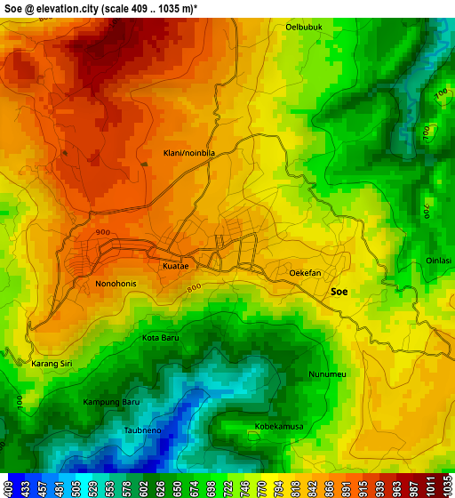
Below is the Elevation map of Soe, which displays elevation range with different colors. Scale of the first map is from 409 to 1035 m (1342 to 3396 ft) with average elevation of 759.3 meters (=2491 ft) [note 1]
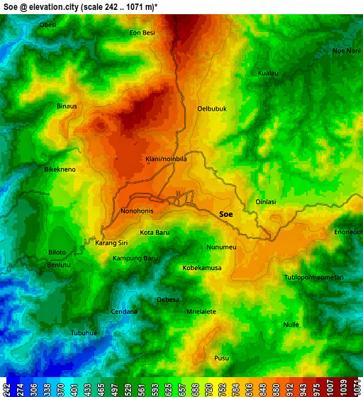
These maps also provides idea of topography and contour of this city, they are displayed at different zoom levels. More info about maps, scale and edge coordinates you can find below images.
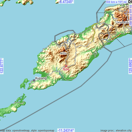
| \ | Map #1 | Map #2 | Topo.Map |
| Scale [m] | 409..1035 m | 242..1071 m | × |
| Scale [ft] | 1342..3396 ft | 794..3514 ft | × |
| Average | 759.3 m = 2491 ft | 642.8 m = 2109 ft | × |
| Width | 9.63 km = 6 mi | 19.26 km = 12 mi | 308.1 km = 191.4 mi |
| Height | 9.63 km = 6 mi | 19.26 km = 12 mi | 308.1 km = 191.4 mi |
| ↑Max Latitude | -9.817411° | -9.774106° | -8.47245° |
| Latitude at center | -9.86071° | -9.86071° | -9.86071° |
| ↓Min Latitude | -9.904003° | -9.947291° | -11.24314° |
| ← Min Longitude | 124.240005° | 124.196059° | 122.8777° |
| Longitude center | 124.28395° | 124.28395° | 124.28395° |
| →Max Longitude | 124.327895° | 124.371841° | 125.6902° |
Nearby cities:
Cities around Soe sort by population:
• Eban elevation 1053 m
34.4 km,  7°
7°
• Oinlasi 905 m
31.8 km,  87°
87°
• Kie 790 m
29 km, 86°
• Polen 351 m
28.9 km,  48°
48°
• Takari 146 m
28.8 km,  244°
244°
• Kuanfatu 431 m
25.5 km,  135°
135°
• Panite 61 m
24.1 km,  194°
194°
• Nikiniki 748 m
21.7 km,  76°
76°
• Kapan 1080 m
14 km,  355°
355°
• Siso 629 m
7 km,  259°
259°
• Neonmat 812 m
5.5 km,  107°
107°
• Oekamusa 789 m
2.9 km,  122°
122°
Multilingual:
 En español:
Soe elevación 852 m.
 En France:
Soe élévation 852 m.


Sources and notes:
- [note 1] Map square and city borders are not equal. Map elevation data is calculated only from area inside that square.
- [src 1] Elevation data from geonames database provided with same terms of usage.
- [src 2] The elevation map of Soe is generated using elevation data from NASA's 3 arcsec (90m) resolution SRTM data.
- [src 3] Base (background) map © OpenStreetMap contributors tiles are generated by Geofabrik and OpenTopoMap.
Copyright & License:
This Soe Elevation Map is licensed under CC BY-SA. You may reuse any part from this page, if you give a proper credit by linking to this URL:
 More info on terms of use page.