Solok elevation
Solok (West Sumatra), Indonesia elevation is 392 meters and Solok elevation in feet is 1286 ft above sea level [src 1]. Solok is a seat of a second-order administrative division (feature code) with elevation that is 201 meters (659 ft) bigger than average city elevation in Indonesia.
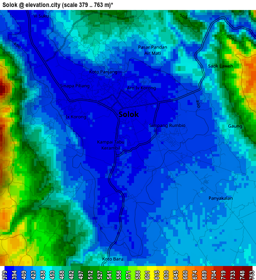
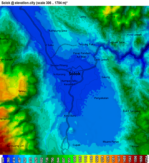
Below is the Elevation map of Solok, which displays elevation range with different colors. Scale of the first map is from 379 to 763 m (1243 to 2503 ft) with average elevation of 445 meters (=1460 ft) [note 1]
These maps also provides idea of topography and contour of this city, they are displayed at different zoom levels. More info about maps, scale and edge coordinates you can find below images.
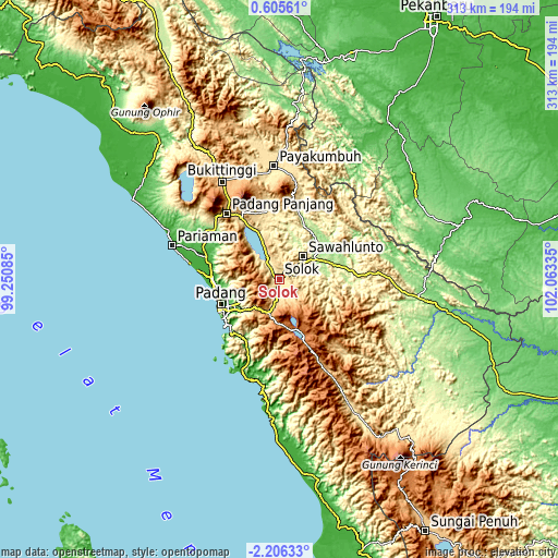
| \ | Map #1 | Map #2 | Topo.Map |
| Scale [m] | 379..763 m | 306..1704 m | × |
| Scale [ft] | 1243..2503 ft | 1004..5591 ft | × |
| Average | 445 m = 1460 ft | 618 m = 2028 ft | × |
| Width | 9.77 km = 6.1 mi | 19.54 km = 12.1 mi | 312.7 km = 194.3 mi |
| Height | 9.77 km = 6.1 mi | 19.54 km = 12.1 mi | 312.7 km = 194.3 mi |
| ↑Max Latitude | -0.756659° | -0.712717° | 0.60561° |
| Latitude at center | -0.8006° | -0.8006° | -0.8006° |
| ↓Min Latitude | -0.844541° | -0.888481° | -2.20633° |
| ← Min Longitude | 100.613155° | 100.569209° | 99.25085° |
| Longitude center | 100.6571° | 100.6571° | 100.6571° |
| →Max Longitude | 100.701045° | 100.744991° | 102.06335° |
Nearby cities:
Cities around Solok sort by population:
• Alahanpanjang elevation 1414 m
34.1 km,  153°
153°
• Kumanis 208 m
33.9 km,  34°
34°
• Lubukbergalung 20 m
33.7 km,  238°
238°
• Kototujuh 202 m
31.6 km,  54°
54°
• Tanjungampalu 270 m
27.3 km,  43°
43°
• Tanjungampalu 285 m
26.2 km, 46°
• Talawi 219 m
24.4 km,  22°
22°
• Sulitair 492 m
20.9 km,  357°
357°
• Arosuka 1023 m
17.3 km,  193°
193°
• Sirukam 776 m
14.9 km,  130°
130°
• Singkarak 397 m
13.6 km,  333°
333°
• Gunung Talang 729 m
12.1 km,  195°
195°
Multilingual:
 En español:
Solok elevación 392 m.
 En France:
Solok élévation 392 m.


Sources and notes:
- [note 1] Map square and city borders are not equal. Map elevation data is calculated only from area inside that square.
- [src 1] Elevation data from geonames database provided with same terms of usage.
- [src 2] The elevation map of Solok is generated using elevation data from NASA's 3 arcsec (90m) resolution SRTM data.
- [src 3] Base (background) map © OpenStreetMap contributors tiles are generated by Geofabrik and OpenTopoMap.
Copyright & License:
This Solok Elevation Map is licensed under CC BY-SA. You may reuse any part from this page, if you give a proper credit by linking to this URL:
 More info on terms of use page.