Tomohon elevation
Tomohon (North Sulawesi), Indonesia elevation is 734 meters and Tomohon elevation in feet is 2408 ft above sea level [src 1]. Tomohon is a seat of a third-order administrative division (feature code) with elevation that is 543 meters (1781 ft) bigger than average city elevation in Indonesia.
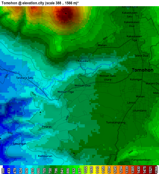
Below is the Elevation map of Tomohon, which displays elevation range with different colors. Scale of the first map is from 388 to 1566 m (1273 to 5138 ft) with average elevation of 747.5 meters (=2452 ft) [note 1]
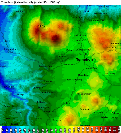
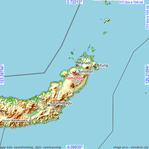
These maps also provides idea of topography and contour of this city, they are displayed at different zoom levels. More info about maps, scale and edge coordinates you can find below images.
| \ | Map #1 | Map #2 | Topo.Map |
| Scale [m] | 388..1566 m | 129..1566 m | × |
| Scale [ft] | 1273..5138 ft | 423..5138 ft | × |
| Average | 747.5 m = 2452 ft | 696.3 m = 2284 ft | × |
| Width | 9.77 km = 6.1 mi | 19.54 km = 12.1 mi | 312.6 km = 194.2 mi |
| Height | 9.77 km = 6.1 mi | 19.54 km = 12.1 mi | 312.6 km = 194.2 mi |
| ↑Max Latitude | 1.360713° | 1.404646° | 2.72212° |
| Latitude at center | 1.31678° | 1.31678° | 1.31678° |
| ↓Min Latitude | 1.272846° | 1.228911° | -0.08935° |
| ← Min Longitude | 124.759845° | 124.715899° | 123.39754° |
| Longitude center | 124.80379° | 124.80379° | 124.80379° |
| →Max Longitude | 124.847735° | 124.891681° | 126.21004° |
Nearby cities:
Cities around Tomohon sort by population:
• Manado elevation 10 m
19.1 km,  15°
15°
• Tondano 693 m
12.2 km,  95°
95°
• Laikit, Laikit II (Dimembe) 288 m
26.9 km,  44°
44°
• Kema 8 m
30.6 km,  79°
79°
• Ratahan 352 m
29.1 km,  180°
180°
• Tatelu 111 m
28.7 km,  33°
33°
• Kauditan 198 m
26.9 km,  72°
72°
• Airmadidi 244 m
23 km,  57°
57°
• Tanahwangko 12 m
16 km,  302°
302°
• Kawangkoan 709 m
12.6 km,  190°
190°
• Pineleng 201 m
12.6 km, 17°
• Sonder 562 m
7.4 km,  201°
201°
Multilingual:
 En español:
Tomohon elevación 734 m.
 En France:
Tomohon élévation 734 m.


Sources and notes:
- [note 1] Map square and city borders are not equal. Map elevation data is calculated only from area inside that square.
- [src 1] Elevation data from geonames database provided with same terms of usage.
- [src 2] The elevation map of Tomohon is generated using elevation data from NASA's 3 arcsec (90m) resolution SRTM data.
- [src 3] Base (background) map © OpenStreetMap contributors tiles are generated by Geofabrik and OpenTopoMap.
Copyright & License:
This Tomohon Elevation Map is licensed under CC BY-SA. You may reuse any part from this page, if you give a proper credit by linking to this URL:
 More info on terms of use page.