Bandar elevation
Bandar (North Sumatra), Indonesia elevation is 73 meters and Bandar elevation in feet is 240 ft above sea level [src 1]. Bandar is a populated place (feature code) with elevation that is 118 meters (387 ft) smaller than average city elevation in Indonesia.
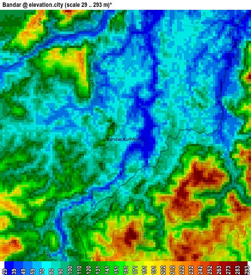
Below is the Elevation map of Bandar, which displays elevation range with different colors. Scale of the first map is from 29 to 293 m (95 to 961 ft) with average elevation of 110.6 meters (=363 ft) [note 1]
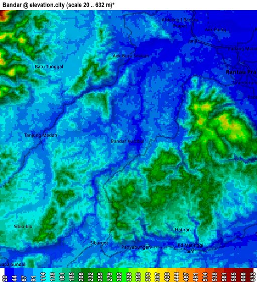
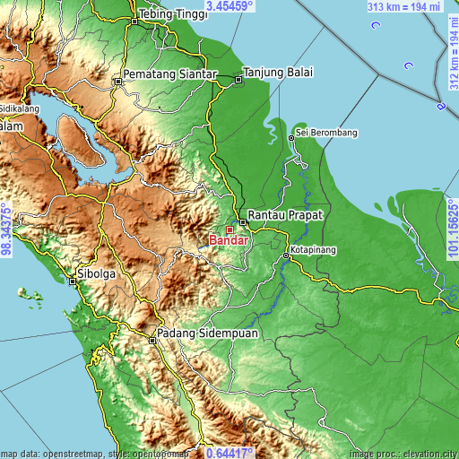
These maps also provides idea of topography and contour of this city, they are displayed at different zoom levels. More info about maps, scale and edge coordinates you can find below images.
| \ | Map #1 | Map #2 | Topo.Map |
| Scale [m] | 29..293 m | 20..632 m | × |
| Scale [ft] | 95..961 ft | 66..2073 ft | × |
| Average | 110.6 m = 363 ft | 116.3 m = 382 ft | × |
| Width | 9.77 km = 6.1 mi | 19.53 km = 12.1 mi | 312.5 km = 194.2 mi |
| Height | 9.77 km = 6.1 mi | 19.53 km = 12.1 mi | 312.5 km = 194.2 mi |
| ↑Max Latitude | 2.093917° | 2.137832° | 3.45459° |
| Latitude at center | 2.05° | 2.05° | 2.05° |
| ↓Min Latitude | 2.006082° | 1.962163° | 0.64417° |
| ← Min Longitude | 99.706055° | 99.662109° | 98.34375° |
| Longitude center | 99.75° | 99.75° | 99.75° |
| →Max Longitude | 99.793945° | 99.837891° | 101.15625° |
Nearby cities:
Cities around Bandar sort by population:
• Rantauprapat elevation 29 m
10.8 km,  59°
59°
• Sarulla 468 m
76.6 km,  247°
247°
• Sipirok 926 m
72.6 km,  226°
226°
• Binanga 60 m
71.2 km,  177°
177°
• Gunung Tua 104 m
61.3 km,  192°
192°
• Aek Kanopan 26 m
58.8 km,  349°
349°
• Sipagimbar 947 m
48.6 km,  239°
239°
• Rantau Prapat 10 m
45.9 km,  46°
46°
• Langgapayung 36 m
43 km,  146°
146°
• Kota Pinang 23 m
41.9 km,  114°
114°
• Sipiongot 123 m
25.8 km,  202°
202°
• Panyabungan 100 m
14.7 km,  206°
206°
Multilingual:
 En español:
Bandar elevación 73 m.
 En France:
Bandar élévation 73 m.


Sources and notes:
- [note 1] Map square and city borders are not equal. Map elevation data is calculated only from area inside that square.
- [src 1] Elevation data from geonames database provided with same terms of usage.
- [src 2] The elevation map of Bandar is generated using elevation data from NASA's 3 arcsec (90m) resolution SRTM data.
- [src 3] Base (background) map © OpenStreetMap contributors tiles are generated by Geofabrik and OpenTopoMap.
Copyright & License:
This Bandar Elevation Map is licensed under CC BY-SA. You may reuse any part from this page, if you give a proper credit by linking to this URL:
 More info on terms of use page.