Kabanjahe elevation
Kabanjahe (North Sumatra), Indonesia elevation is 1196 meters and Kabanjahe elevation in feet is 3924 ft above sea level [src 1]. Kabanjahe is a seat of a second-order administrative division (feature code) with elevation that is 1005 meters (3297 ft) bigger than average city elevation in Indonesia.
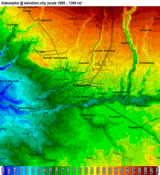
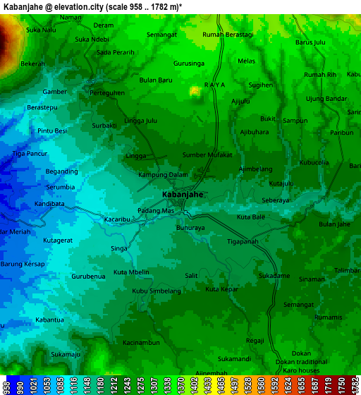
Below is the Elevation map of Kabanjahe, which displays elevation range with different colors. Scale of the first map is from 1089 to 1305 m (3573 to 4281 ft) with average elevation of 1197.6 meters (=3929 ft) [note 1]
These maps also provides idea of topography and contour of this city, they are displayed at different zoom levels. More info about maps, scale and edge coordinates you can find below images.
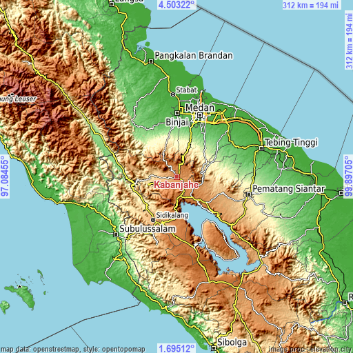
| \ | Map #1 | Map #2 | Topo.Map |
| Scale [m] | 1089..1305 m | 958..1782 m | × |
| Scale [ft] | 3573..4281 ft | 3143..5846 ft | × |
| Average | 1197.6 m = 3929 ft | 1221.1 m = 4006 ft | × |
| Width | 9.76 km = 6.1 mi | 19.52 km = 12.1 mi | 312.2 km = 194 mi |
| Height | 9.76 km = 6.1 mi | 19.52 km = 12.1 mi | 312.3 km = 194.1 mi |
| ↑Max Latitude | 3.14398° | 3.187858° | 4.50322° |
| Latitude at center | 3.1001° | 3.1001° | 3.1001° |
| ↓Min Latitude | 3.056218° | 3.012334° | 1.69512° |
| ← Min Longitude | 98.446855° | 98.402909° | 97.08455° |
| Longitude center | 98.4908° | 98.4908° | 98.4908° |
| →Max Longitude | 98.534745° | 98.578691° | 99.89705° |
Nearby cities:
Cities around Kabanjahe sort by population:
• Berastagi elevation 1402 m
10.7 km,  10°
10°
• Deli Tua 56 m
50.1 km,  25°
25°
• Tongging 926 m
22.7 km,  170°
170°
• Sukarama 813 m
54.6 km,  202°
202°
• Sarimatondang 847 m
54 km,  119°
119°
• Sipintuangin 1218 m
46.1 km,  133°
133°
• Sidikalang 1066 m
43.8 km,  206°
206°
• Sondi 1010 m
43.5 km,  108°
108°
• Pematang Raya 1013 m
42.3 km, 110°
• Sumbul 1009 m
41.3 km,  194°
194°
• Tigarunggu 1313 m
34.3 km, 131°
• Saribudolok 1411 m
22.3 km,  143°
143°
Multilingual:
 En español:
Kabanjahe elevación 1196 m.
 En France:
Kabanjahe élévation 1196 m.
 Auf Deutsch:
Kabanjahe höhe über dem Meeresspiegel ist 1196 m.

Sources and notes:
- [note 1] Map square and city borders are not equal. Map elevation data is calculated only from area inside that square.
- [src 1] Elevation data from geonames database provided with same terms of usage.
- [src 2] The elevation map of Kabanjahe is generated using elevation data from NASA's 3 arcsec (90m) resolution SRTM data.
- [src 3] Base (background) map © OpenStreetMap contributors tiles are generated by Geofabrik and OpenTopoMap.
Copyright & License:
This Kabanjahe Elevation Map is licensed under CC BY-SA. You may reuse any part from this page, if you give a proper credit by linking to this URL:
 More info on terms of use page.