Lhokseumawe elevation
Lhokseumawe (Aceh), Indonesia elevation is 6 meters and Lhokseumawe elevation in feet is 20 ft above sea level [src 1]. Lhokseumawe is a populated place (feature code) with elevation that is 185 meters (607 ft) smaller than average city elevation in Indonesia.
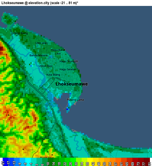
Below is the Elevation map of Lhokseumawe, which displays elevation range with different colors. Scale of the first map is from -21 to 81 m (-69 to 266 ft) with average elevation of 15.3 meters (=50 ft) [note 1]
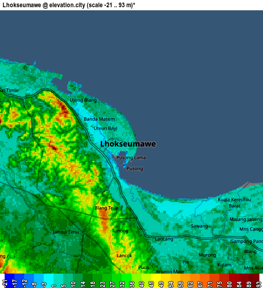
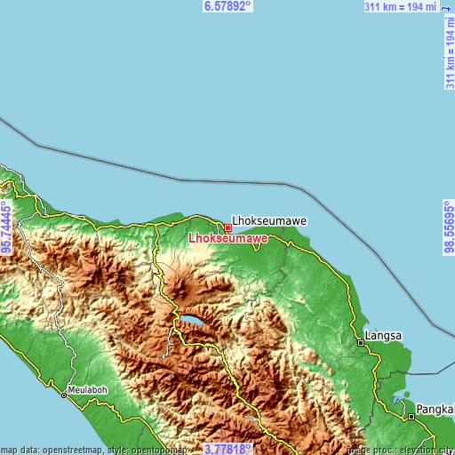
These maps also provides idea of topography and contour of this city, they are displayed at different zoom levels. More info about maps, scale and edge coordinates you can find below images.
| \ | Map #1 | Map #2 | Topo.Map |
| Scale [m] | -21..81 m | -21..93 m | × |
| Scale [ft] | -69..266 ft | -69..305 ft | × |
| Average | 15.3 m = 50 ft | 16.8 m = 55 ft | × |
| Width | 9.73 km = 6 mi | 19.47 km = 12.1 mi | 311.4 km = 193.5 mi |
| Height | 9.73 km = 6 mi | 19.47 km = 12.1 mi | 311.4 km = 193.5 mi |
| ↑Max Latitude | 5.223864° | 5.267626° | 6.57892° |
| Latitude at center | 5.1801° | 5.1801° | 5.1801° |
| ↓Min Latitude | 5.136333° | 5.092562° | 3.77818° |
| ← Min Longitude | 97.106755° | 97.062809° | 95.74445° |
| Longitude center | 97.1507° | 97.1507° | 97.1507° |
| →Max Longitude | 97.194645° | 97.238591° | 98.55695° |
Nearby cities:
Cities around Lhokseumawe sort by population:
• Simpang Ulim elevation 5 m
46 km,  98°
98°
• Blang Mane 249 m
45.7 km,  246°
246°
• Alue Glumpang 58 m
44.2 km,  255°
255°
• Jumpangdua 10 m
40.6 km,  272°
272°
• Bulahblangaro 125 m
34.6 km, 252°
• Cot Baroh 7 m
34.5 km,  276°
276°
• Seunudon 4 m
33.2 km,  84°
84°
• Adil Makmur 11 m
31.1 km, 273°
• Matangkuli 6 m
22.1 km,  138°
138°
• Blang Ara 109 m
15.5 km,  240°
240°
• Matangpayang 10 m
12.5 km,  118°
118°
• Blangpulo 10 m
8.6 km,  290°
290°
Multilingual:
 En español:
Lhokseumawe elevación 6 m.
 En France:
Lhokseumawe élévation 6 m.
 Auf Deutsch:
Lhokseumawe höhe über dem Meeresspiegel ist 6 m.

Sources and notes:
- [note 1] Map square and city borders are not equal. Map elevation data is calculated only from area inside that square.
- [src 1] Elevation data from geonames database provided with same terms of usage.
- [src 2] The elevation map of Lhokseumawe is generated using elevation data from NASA's 3 arcsec (90m) resolution SRTM data.
- [src 3] Base (background) map © OpenStreetMap contributors tiles are generated by Geofabrik and OpenTopoMap.
Copyright & License:
This Lhokseumawe Elevation Map is licensed under CC BY-SA. You may reuse any part from this page, if you give a proper credit by linking to this URL:
 More info on terms of use page.