Meulaboh elevation
Meulaboh (Aceh), Indonesia elevation is 7 meters and Meulaboh elevation in feet is 23 ft above sea level [src 1]. Meulaboh is a seat of a second-order administrative division (feature code) with elevation that is 184 meters (604 ft) smaller than average city elevation in Indonesia.
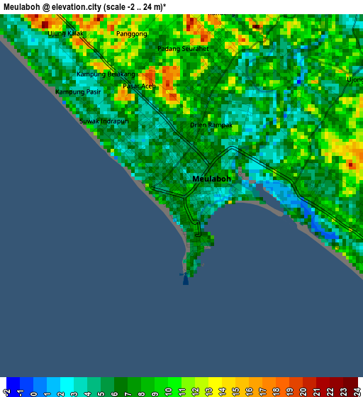
Below is the Elevation map of Meulaboh, which displays elevation range with different colors. Scale of the first map is from -2 to 24 m (-7 to 79 ft) with average elevation of 7.2 meters (=24 ft) [note 1]
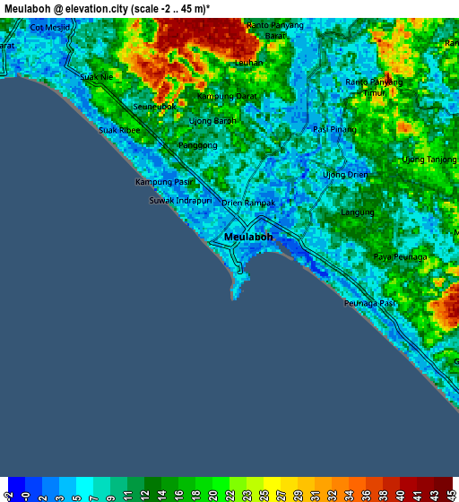
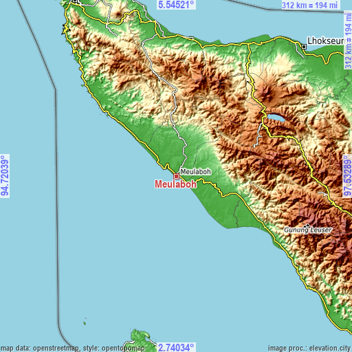
These maps also provides idea of topography and contour of this city, they are displayed at different zoom levels. More info about maps, scale and edge coordinates you can find below images.
| \ | Map #1 | Map #2 | Topo.Map |
| Scale [m] | -2..24 m | -2..45 m | × |
| Scale [ft] | -7..79 ft | -7..148 ft | × |
| Average | 7.2 m = 24 ft | 13.1 m = 43 ft | × |
| Width | 9.75 km = 6.1 mi | 19.49 km = 12.1 mi | 311.9 km = 193.8 mi |
| Height | 9.75 km = 6.1 mi | 19.49 km = 12.1 mi | 311.9 km = 193.8 mi |
| ↑Max Latitude | 4.187849° | 4.231676° | 5.54521° |
| Latitude at center | 4.14402° | 4.14402° | 4.14402° |
| ↓Min Latitude | 4.100188° | 4.056354° | 2.74034° |
| ← Min Longitude | 96.082695° | 96.038749° | 94.72039° |
| Longitude center | 96.12664° | 96.12664° | 96.12664° |
| →Max Longitude | 96.170585° | 96.214531° | 97.53289° |
Nearby cities:
Cities around Meulaboh sort by population:
• Suka Makmue elevation 32 m
56.7 km,  106°
106°
• Alue Bilie 42 m
50.5 km, 107°
• Kajeung 47 m
41.1 km,  0°
0°
• Beutong Ateuh 97 m
36.5 km,  70°
70°
• Blang Ara 49 m
31.1 km,  60°
60°
• Kuala Bhee 17 m
28.3 km,  341°
341°
• Drien Rampak 9 m
26.3 km,  314°
314°
• Pantai Ceuremen 22 m
26.2 km,  16°
16°
• Kuala Tuha 7 m
16.1 km,  125°
125°
• Banda Layung 32 m
11.3 km, 343°
• Keudee Aron 6 m
9.7 km,  36°
36°
• Meureubo 8 m
4 km,  96°
96°
Multilingual:
 En español:
Meulaboh elevación 7 m.
 En France:
Meulaboh élévation 7 m.


Sources and notes:
- [note 1] Map square and city borders are not equal. Map elevation data is calculated only from area inside that square.
- [src 1] Elevation data from geonames database provided with same terms of usage.
- [src 2] The elevation map of Meulaboh is generated using elevation data from NASA's 3 arcsec (90m) resolution SRTM data.
- [src 3] Base (background) map © OpenStreetMap contributors tiles are generated by Geofabrik and OpenTopoMap.
Copyright & License:
This Meulaboh Elevation Map is licensed under CC BY-SA. You may reuse any part from this page, if you give a proper credit by linking to this URL:
 More info on terms of use page.