Pintupadang elevation
Pintupadang (North Sumatra), Indonesia elevation is 260 meters and Pintupadang elevation in feet is 853 ft above sea level [src 1]. Pintupadang is a seat of a third-order administrative division (feature code) with elevation that is 69 meters (226 ft) bigger than average city elevation in Indonesia.
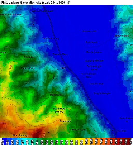
Below is the Elevation map of Pintupadang, which displays elevation range with different colors. Scale of the first map is from 214 to 1430 m (702 to 4692 ft) with average elevation of 466 meters (=1529 ft) [note 1]
These maps also provides idea of topography and contour of this city, they are displayed at different zoom levels. More info about maps, scale and edge coordinates you can find below images.
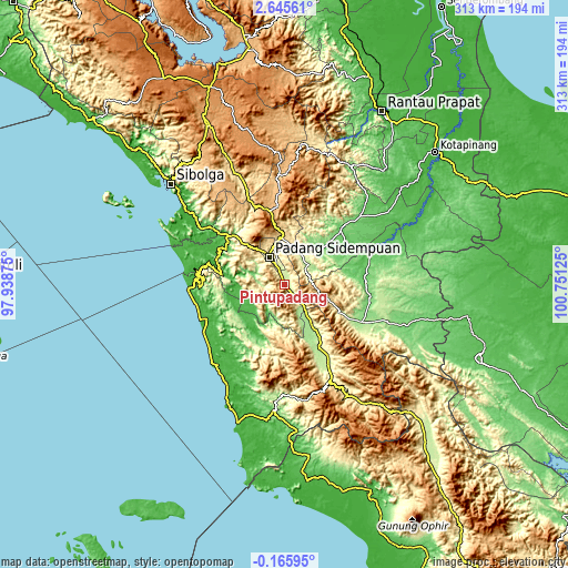
| \ | Map #1 | Topo.Map |
| Scale [m] | 214..1430 m | × |
| Scale [ft] | 702..4692 ft | × |
| Average | 466 m = 1529 ft | × |
| Width | 9.77 km = 6.1 mi | 312.6 km = 194.2 mi |
| Height | 9.77 km = 6.1 mi | 312.6 km = 194.2 mi |
| ↑Max Latitude | 1.284135° | 2.64561° |
| Latitude at center | 1.2402° | 1.2402° |
| ↓Min Latitude | 1.196265° | -0.16595° |
| ← Min Longitude | 99.301055° | 97.93875° |
| Longitude center | 99.345° | 99.345° |
| →Max Longitude | 99.388945° | 100.75125° |
Nearby cities:
Cities around Pintupadang sort by population:
• Padangsidempuan elevation 310 m
17.5 km,  332°
332°
• Ujungbatu 108 m
69.1 km,  108°
108°
• Sarulla 468 m
65.9 km,  337°
337°
• Sipagimbar 947 m
65.7 km,  2°
2°
• Muara Soma 144 m
61.4 km,  178°
178°
• Binanga 60 m
51.5 km,  68°
68°
• Panyambungan 213 m
47.7 km,  151°
151°
• Sibuhuan 153 m
47.6 km,  115°
115°
• Gunung Tua 104 m
43.5 km,  45°
45°
• Sipirok 926 m
41.1 km,  348°
348°
• Batangtoru 84 m
41.1 km,  310°
310°
• Siabu 184 m
30 km, 146°
Multilingual:
 En español:
Pintupadang elevación 260 m.
 En France:
Pintupadang élévation 260 m.
 Auf Deutsch:
Pintupadang höhe über dem Meeresspiegel ist 260 m.

Sources and notes:
- [note 1] Map square and city borders are not equal. Map elevation data is calculated only from area inside that square.
- [src 1] Elevation data from geonames database provided with same terms of usage.
- [src 2] The elevation map of Pintupadang is generated using elevation data from NASA's 3 arcsec (90m) resolution SRTM data.
- [src 3] Base (background) map © OpenStreetMap contributors tiles are generated by Geofabrik and OpenTopoMap.
Copyright & License:
This Pintupadang Elevation Map is licensed under CC BY-SA. You may reuse any part from this page, if you give a proper credit by linking to this URL:
 More info on terms of use page.