Ilaga elevation
Ilaga (Papua), Indonesia elevation is 3185 meters and Ilaga elevation in feet is 10449 ft above sea level [src 1]. Ilaga is a seat of a second-order administrative division (feature code) with elevation that is 2994 meters (9823 ft) bigger than average city elevation in Indonesia.
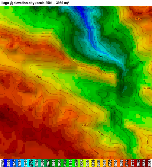
Below is the Elevation map of Ilaga, which displays elevation range with different colors. Scale of the first map is from 2501 to 3939 m (8205 to 12923 ft) with average elevation of 3363.6 meters (=11035 ft) [note 1]
These maps also provides idea of topography and contour of this city, they are displayed at different zoom levels. More info about maps, scale and edge coordinates you can find below images.
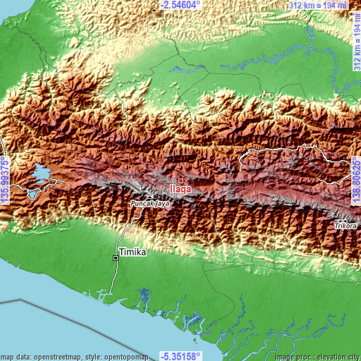
| \ | Map #1 | Topo.Map |
| Scale [m] | 2501..3939 m | × |
| Scale [ft] | 8205..12923 ft | × |
| Average | 3363.6 m = 11035 ft | × |
| Width | 9.75 km = 6.1 mi | 311.9 km = 193.8 mi |
| Height | 9.75 km = 6.1 mi | 312 km = 193.9 mi |
| ↑Max Latitude | -3.906158° | -2.54604° |
| Latitude at center | -3.95° | -3.95° |
| ↓Min Latitude | -3.99384° | -5.35158° |
| ← Min Longitude | 137.356055° | 135.99375° |
| Longitude center | 137.4° | 137.4° |
| →Max Longitude | 137.443945° | 138.80625° |
Nearby cities:
Cities around Ilaga sort by population:
• Tigi elevation 1772 m
125.7 km,  269°
269°
• Waghete 1709 m
125.2 km, 265°
• Karubaga 1781 m
120.6 km,  76°
76°
• Tiom 2116 m
117 km,  88°
88°
• Enarotali 1788 m
113.6 km, 271°
• Homeyo 1359 m
108.1 km,  287°
287°
• Mapurujaya 11 m
102.5 km,  218°
218°
• Kumopa 2450 m
99.8 km,  278°
278°
• Bilogai 1624 m
85.2 km, 287°
• Mulia 2106 m
70 km,  68°
68°
• Sugapa 2144 m
45.1 km,  300°
300°
• Beoga 3019 m
28.6 km, 295°
Multilingual:
 En español:
Ilaga elevación 3185 m.
 En France:
Ilaga élévation 3185 m.


Sources and notes:
- [note 1] Map square and city borders are not equal. Map elevation data is calculated only from area inside that square.
- [src 1] Elevation data from geonames database provided with same terms of usage.
- [src 2] The elevation map of Ilaga is generated using elevation data from NASA's 3 arcsec (90m) resolution SRTM data.
- [src 3] Base (background) map © OpenStreetMap contributors tiles are generated by Geofabrik and OpenTopoMap.
Copyright & License:
This Ilaga Elevation Map is licensed under CC BY-SA. You may reuse any part from this page, if you give a proper credit by linking to this URL:
 More info on terms of use page.