Loang elevation
Loang (East Nusa Tenggara), Indonesia elevation is 28 meters and Loang elevation in feet is 92 ft above sea level [src 1]. Loang is a seat of a third-order administrative division (feature code) with elevation that is 163 meters (535 ft) smaller than average city elevation in Indonesia.
Below is the Elevation map of Loang, which displays elevation range with different colors. Scale of the first map is from -4 to 1003 m (-13 to 3291 ft) with average elevation of 174.1 meters (=571 ft) [note 1]
These maps also provides idea of topography and contour of this city, they are displayed at different zoom levels. More info about maps, scale and edge coordinates you can find below images.
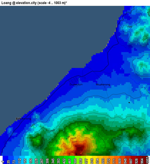
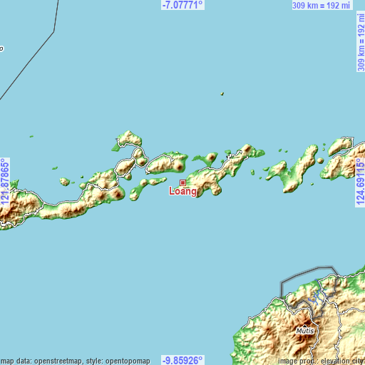
| \ | Map #1 | Topo.Map |
| Scale [m] | -4..1003 m | × |
| Scale [ft] | -13..3291 ft | × |
| Average | 174.1 m = 571 ft | × |
| Width | 9.67 km = 6 mi | 309.3 km = 192.2 mi |
| Height | 9.67 km = 6 mi | 309.3 km = 192.2 mi |
| ↑Max Latitude | -8.427532° | -7.07771° |
| Latitude at center | -8.471° | -8.471° |
| ↓Min Latitude | -8.514463° | -9.85926° |
| ← Min Longitude | 123.240955° | 121.87865° |
| Longitude center | 123.2849° | 123.2849° |
| →Max Longitude | 123.328845° | 124.69115° |
Nearby cities:
Cities around Loang sort by population:
• Larantuka elevation 28 m
35 km,  297°
297°
• Hadakewa 18 m
31 km,  68°
68°
• Waiwadan 16 m
30.3 km,  315°
315°
• Waipukang 17 m
25.8 km,  49°
49°
• Baniona 27 m
23.4 km,  289°
289°
• Menanga 23 m
22.1 km,  280°
280°
• Watugolok 596 m
21 km,  80°
80°
• Klubagolit 260 m
20.2 km,  342°
342°
• Witihama 175 m
19.2 km,  352°
352°
• Lewoleba 19 m
18.3 km, 53°
• Waiwerang 28 m
16.1 km, 304°
• Senadan 97 m
10 km, 342°
Multilingual:
 En español:
Loang elevación 28 m.
 En France:
Loang élévation 28 m.


Sources and notes:
- [note 1] Map square and city borders are not equal. Map elevation data is calculated only from area inside that square.
- [src 1] Elevation data from geonames database provided with same terms of usage.
- [src 2] The elevation map of Loang is generated using elevation data from NASA's 3 arcsec (90m) resolution SRTM data.
- [src 3] Base (background) map © OpenStreetMap contributors tiles are generated by Geofabrik and OpenTopoMap.
Copyright & License:
This Loang Elevation Map is licensed under CC BY-SA. You may reuse any part from this page, if you give a proper credit by linking to this URL:
 More info on terms of use page.