Bolou elevation
Bolou (East Nusa Tenggara), Indonesia elevation is 84 meters and Bolou elevation in feet is 276 ft above sea level [src 1]. Bolou is a seat of a third-order administrative division (feature code) with elevation that is 107 meters (351 ft) smaller than average city elevation in Indonesia.
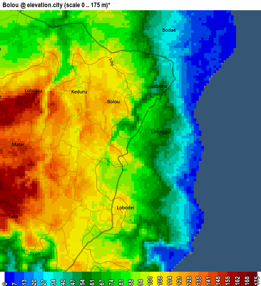
Below is the Elevation map of Bolou, which displays elevation range with different colors. Scale of the first map is from 0 to 175 m (0 to 574 ft) with average elevation of 84.5 meters (=277 ft) [note 1]
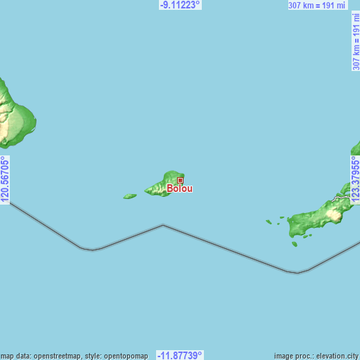
These maps also provides idea of topography and contour of this city, they are displayed at different zoom levels. More info about maps, scale and edge coordinates you can find below images.
| \ | Map #1 | Topo.Map |
| Scale [m] | 0..175 m | × |
| Scale [ft] | 0..574 ft | × |
| Average | 84.5 m = 277 ft | × |
| Width | 9.61 km = 6 mi | 307.5 km = 191.1 mi |
| Height | 9.61 km = 6 mi | 307.5 km = 191.1 mi |
| ↑Max Latitude | -10.454687° | -9.11223° |
| Latitude at center | -10.4979° | -10.4979° |
| ↓Min Latitude | -10.541107° | -11.87739° |
| ← Min Longitude | 121.929355° | 120.56705° |
| Longitude center | 121.9733° | 121.9733° |
| →Max Longitude | 122.017245° | 123.37955° |
Nearby cities:
Cities around Bolou sort by population:
• Uitao elevation 32 m
160.5 km,  77°
77°
• Eahun 51 m
154.9 km,  94°
94°
• Ngalu 37 m
143.8 km,  285°
285°
• Olafulihaa 79 m
138.7 km,  96°
96°
• Momanalu 30 m
129 km, 98°
• Likioen 98 m
120.3 km, 103°
• Baa 12 m
120.3 km, 102°
• Busalangga 136 m
117.6 km,  106°
106°
• Batutua 19 m
117.5 km, 109°
• Ledeunu 15 m
41.4 km,  253°
253°
• Loboae 21 m
15.9 km,  267°
267°
• Seba 11 m
14.7 km, 271°
Multilingual:
 En español:
Bolou elevación 84 m.
 En France:
Bolou élévation 84 m.


Sources and notes:
- [note 1] Map square and city borders are not equal. Map elevation data is calculated only from area inside that square.
- [src 1] Elevation data from geonames database provided with same terms of usage.
- [src 2] The elevation map of Bolou is generated using elevation data from NASA's 3 arcsec (90m) resolution SRTM data.
- [src 3] Base (background) map © OpenStreetMap contributors tiles are generated by Geofabrik and OpenTopoMap.
Copyright & License:
This Bolou Elevation Map is licensed under CC BY-SA. You may reuse any part from this page, if you give a proper credit by linking to this URL:
 More info on terms of use page.