Cigugur elevation
Cigugur (West Java), Indonesia elevation is 145 meters and Cigugur elevation in feet is 476 ft above sea level [src 1]. Cigugur is a seat of a third-order administrative division (feature code) with elevation that is 46 meters (151 ft) smaller than average city elevation in Indonesia.
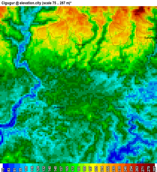
Below is the Elevation map of Cigugur, which displays elevation range with different colors. Scale of the first map is from 75 to 287 m (246 to 942 ft) with average elevation of 150.7 meters (=494 ft) [note 1]
These maps also provides idea of topography and contour of this city, they are displayed at different zoom levels. More info about maps, scale and edge coordinates you can find below images.
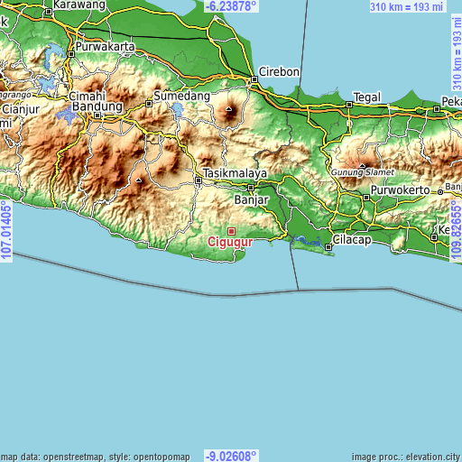
| \ | Map #1 | Topo.Map |
| Scale [m] | 75..287 m | × |
| Scale [ft] | 246..942 ft | × |
| Average | 150.7 m = 494 ft | × |
| Width | 9.69 km = 6 mi | 309.9 km = 192.6 mi |
| Height | 9.69 km = 6 mi | 309.9 km = 192.6 mi |
| ↑Max Latitude | -7.591142° | -6.23878° |
| Latitude at center | -7.6347° | -7.6347° |
| ↓Min Latitude | -7.678254° | -9.02608° |
| ← Min Longitude | 108.376355° | 107.01405° |
| Longitude center | 108.4203° | 108.4203° |
| →Max Longitude | 108.464245° | 109.82655° |
Nearby cities:
Cities around Cigugur sort by population:
• Cibalong elevation 162 m
29.5 km,  296°
296°
• Banjarsari 27 m
26.1 km,  49°
49°
• Ciriri 305 m
26 km,  345°
345°
• Pananjung 8 m
25.9 km,  101°
101°
• Pamarican 32 m
22.8 km,  30°
30°
• Salopa 292 m
21 km,  308°
308°
• Cikatomas 254 m
17.9 km,  274°
274°
• Cibongas 189 m
16.6 km,  260°
260°
• Limusnunggal 538 m
14.7 km, 352°
• Cimerak 103 m
13.1 km,  170°
170°
• Cijulang 10 m
11.8 km,  150°
150°
• Parigi 11 m
11.2 km,  131°
131°
Multilingual:
 En español:
Cigugur elevación 145 m.
 En France:
Cigugur élévation 145 m.


Sources and notes:
- [note 1] Map square and city borders are not equal. Map elevation data is calculated only from area inside that square.
- [src 1] Elevation data from geonames database provided with same terms of usage.
- [src 2] The elevation map of Cigugur is generated using elevation data from NASA's 3 arcsec (90m) resolution SRTM data.
- [src 3] Base (background) map © OpenStreetMap contributors tiles are generated by Geofabrik and OpenTopoMap.
Copyright & License:
This Cigugur Elevation Map is licensed under CC BY-SA. You may reuse any part from this page, if you give a proper credit by linking to this URL:
 More info on terms of use page.