Sindangtamu elevation
Sindangtamu (West Java), Indonesia elevation is 486 meters and Sindangtamu elevation in feet is 1594 ft above sea level [src 1]. Sindangtamu is a seat of a third-order administrative division (feature code) with elevation that is 295 meters (968 ft) bigger than average city elevation in Indonesia.
Below is the Elevation map of Sindangtamu, which displays elevation range with different colors. Scale of the first map is from 452 to 1116 m (1483 to 3661 ft) with average elevation of 600.3 meters (=1969 ft) [note 1]
These maps also provides idea of topography and contour of this city, they are displayed at different zoom levels. More info about maps, scale and edge coordinates you can find below images.
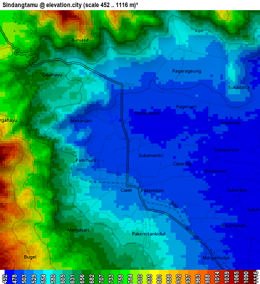
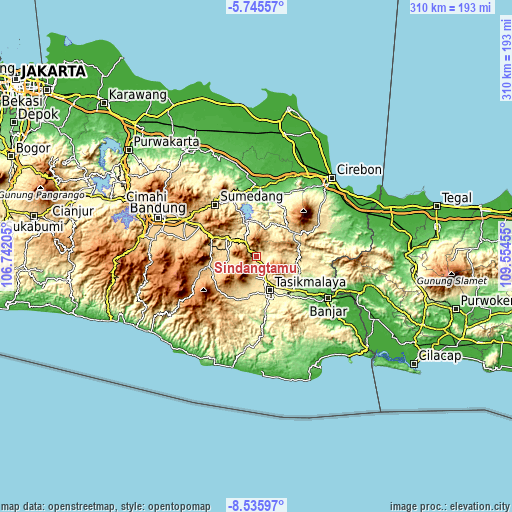
| \ | Map #1 | Topo.Map |
| Scale [m] | 452..1116 m | × |
| Scale [ft] | 1483..3661 ft | × |
| Average | 600.3 m = 1969 ft | × |
| Width | 9.7 km = 6 mi | 310.3 km = 192.8 mi |
| Height | 9.7 km = 6 mi | 310.3 km = 192.8 mi |
| ↑Max Latitude | -7.099294° | -5.74557° |
| Latitude at center | -7.1429° | -7.1429° |
| ↓Min Latitude | -7.186502° | -8.53597° |
| ← Min Longitude | 108.104355° | 106.74205° |
| Longitude center | 108.1483° | 108.1483° |
| →Max Longitude | 108.192245° | 109.55455° |
Nearby cities:
Cities around Sindangtamu sort by population:
• Rajapolah elevation 467 m
9.8 km,  152°
152°
• Gununglimbangan 626 m
18.7 km,  284°
284°
• Sukamaju Kidul 427 m
16.2 km,  164°
164°
• Sukawening 715 m
15.7 km,  264°
264°
• Lemahputih 967 m
15 km,  9°
9°
• Panjalu 742 m
13.1 km,  84°
84°
• Cisayong 561 m
12.7 km,  179°
179°
• Malangbong 614 m
11.4 km,  323°
323°
• Cihaurbeuti 437 m
10.7 km, 146°
• Sukaraja 481 m
7.3 km,  93°
93°
• Jamanis 480 m
6.5 km,  143°
143°
• Pagerageung 548 m
4 km,  31°
31°
Multilingual:
 En español:
Sindangtamu elevación 486 m.
 En France:
Sindangtamu élévation 486 m.
 Auf Deutsch:
Sindangtamu höhe über dem Meeresspiegel ist 486 m.

Sources and notes:
- [note 1] Map square and city borders are not equal. Map elevation data is calculated only from area inside that square.
- [src 1] Elevation data from geonames database provided with same terms of usage.
- [src 2] The elevation map of Sindangtamu is generated using elevation data from NASA's 3 arcsec (90m) resolution SRTM data.
- [src 3] Base (background) map © OpenStreetMap contributors tiles are generated by Geofabrik and OpenTopoMap.
Copyright & License:
This Sindangtamu Elevation Map is licensed under CC BY-SA. You may reuse any part from this page, if you give a proper credit by linking to this URL:
 More info on terms of use page.