Ciwaru elevation
Ciwaru (Banten), Indonesia elevation is 9 meters and Ciwaru elevation in feet is 30 ft above sea level [src 1]. Ciwaru is a seat of a third-order administrative division (feature code) with elevation that is 182 meters (597 ft) smaller than average city elevation in Indonesia.
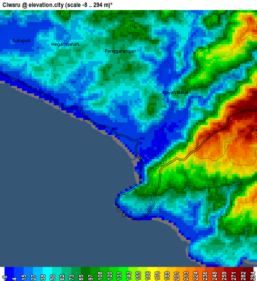
Below is the Elevation map of Ciwaru, which displays elevation range with different colors. Scale of the first map is from -8 to 294 m (-26 to 965 ft) with average elevation of 76.4 meters (=251 ft) [note 1]
These maps also provides idea of topography and contour of this city, they are displayed at different zoom levels. More info about maps, scale and edge coordinates you can find below images.
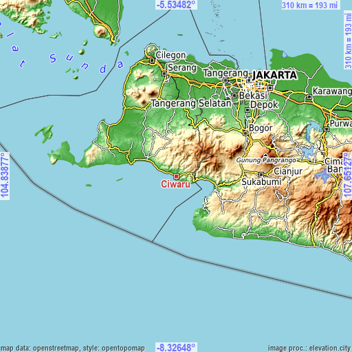
| \ | Map #1 | Topo.Map |
| Scale [m] | -8..294 m | × |
| Scale [ft] | -26..965 ft | × |
| Average | 76.4 m = 251 ft | × |
| Width | 9.7 km = 6 mi | 310.4 km = 192.9 mi |
| Height | 9.7 km = 6 mi | 310.4 km = 192.9 mi |
| ↑Max Latitude | -6.889094° | -5.53482° |
| Latitude at center | -6.93272° | -6.93272° |
| ↓Min Latitude | -6.976342° | -8.32648° |
| ← Min Longitude | 106.201075° | 104.83877° |
| Longitude center | 106.24502° | 106.24502° |
| →Max Longitude | 106.288965° | 107.65127° |
Nearby cities:
Cities around Ciwaru sort by population:
• Pelabuhanratu elevation 21 m
34.4 km,  100°
100°
• Leuwidamar 43 m
47.1 km,  353°
353°
• Cikeusik 23 m
47 km,  298°
298°
• Ciemas 321 m
45.1 km,  137°
137°
• Gunungkencana 278 m
44.3 km,  334°
334°
• Muncang 138 m
43.5 km,  6°
6°
• Bojongmanik Girang 110 m
39.7 km, 347°
• Sukamaju 292 m
31.8 km,  322°
322°
• Pasirgeleng 19 m
29.4 km, 299°
• Cisolok 20 m
22.7 km,  94°
94°
• Warungbanten 608 m
14.5 km,  39°
39°
• Cisiih 7 m
6.6 km, 295°
Multilingual:
 En español:
Ciwaru elevación 9 m.
 En France:
Ciwaru élévation 9 m.


Sources and notes:
- [note 1] Map square and city borders are not equal. Map elevation data is calculated only from area inside that square.
- [src 1] Elevation data from geonames database provided with same terms of usage.
- [src 2] The elevation map of Ciwaru is generated using elevation data from NASA's 3 arcsec (90m) resolution SRTM data.
- [src 3] Base (background) map © OpenStreetMap contributors tiles are generated by Geofabrik and OpenTopoMap.
Copyright & License:
This Ciwaru Elevation Map is licensed under CC BY-SA. You may reuse any part from this page, if you give a proper credit by linking to this URL:
 More info on terms of use page.