Detusoko elevation
Detusoko (East Nusa Tenggara), Indonesia elevation is 751 meters and Detusoko elevation in feet is 2464 ft above sea level [src 1]. Detusoko is a seat of a third-order administrative division (feature code) with elevation that is 560 meters (1837 ft) bigger than average city elevation in Indonesia.
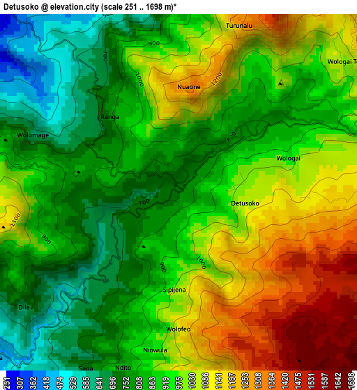
Below is the Elevation map of Detusoko, which displays elevation range with different colors. Scale of the first map is from 251 to 1698 m (823 to 5571 ft) with average elevation of 946.1 meters (=3104 ft) [note 1]
These maps also provides idea of topography and contour of this city, they are displayed at different zoom levels. More info about maps, scale and edge coordinates you can find below images.
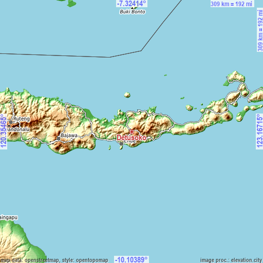
| \ | Map #1 | Topo.Map |
| Scale [m] | 251..1698 m | × |
| Scale [ft] | 823..5571 ft | × |
| Average | 946.1 m = 3104 ft | × |
| Width | 9.66 km = 6 mi | 309.1 km = 192.1 mi |
| Height | 9.66 km = 6 mi | 309.1 km = 192.1 mi |
| ↑Max Latitude | -8.67316° | -7.32414° |
| Latitude at center | -8.7166° | -8.7166° |
| ↓Min Latitude | -8.760035° | -10.10389° |
| ← Min Longitude | 121.716955° | 120.35465° |
| Longitude center | 121.7609° | 121.7609° |
| →Max Longitude | 121.804845° | 123.16715° |
Nearby cities:
Cities around Detusoko sort by population:
• Ende elevation 31 m
17.8 km,  217°
217°
• Lela 14 m
45.3 km,  91°
91°
• Nangaroro 13 m
41.3 km,  259°
259°
• Lekebai 115 m
34.7 km, 89°
• Kotabaru 28 m
34.1 km,  47°
47°
• Paga 9 m
32 km,  102°
102°
• Maurole 10 m
23.3 km,  11°
11°
• Wolowona 28 m
15.9 km, 215°
• Wolowaru 240 m
15.6 km,  118°
118°
• Ndona 108 m
15.4 km,  212°
212°
• Aelande 40 m
14 km,  343°
343°
• Welamosa 45 m
13.2 km, 338°
Multilingual:
 En español:
Detusoko elevación 751 m.
 En France:
Detusoko élévation 751 m.
 Auf Deutsch:
Detusoko höhe über dem Meeresspiegel ist 751 m.

Sources and notes:
- [note 1] Map square and city borders are not equal. Map elevation data is calculated only from area inside that square.
- [src 1] Elevation data from geonames database provided with same terms of usage.
- [src 2] The elevation map of Detusoko is generated using elevation data from NASA's 3 arcsec (90m) resolution SRTM data.
- [src 3] Base (background) map © OpenStreetMap contributors tiles are generated by Geofabrik and OpenTopoMap.
Copyright & License:
This Detusoko Elevation Map is licensed under CC BY-SA. You may reuse any part from this page, if you give a proper credit by linking to this URL:
 More info on terms of use page.