Ritapiret elevation
Ritapiret (East Nusa Tenggara), Indonesia elevation is 287 meters and Ritapiret elevation in feet is 942 ft above sea level [src 1]. Ritapiret is a seat of a third-order administrative division (feature code) with elevation that is 96 meters (315 ft) bigger than average city elevation in Indonesia.
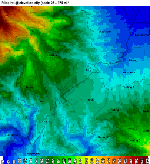
Below is the Elevation map of Ritapiret, which displays elevation range with different colors. Scale of the first map is from 26 to 975 m (85 to 3199 ft) with average elevation of 280.5 meters (=920 ft) [note 1]
These maps also provides idea of topography and contour of this city, they are displayed at different zoom levels. More info about maps, scale and edge coordinates you can find below images.
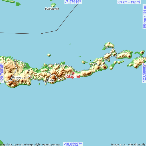
| \ | Map #1 | Topo.Map |
| Scale [m] | 26..975 m | × |
| Scale [ft] | 85..3199 ft | × |
| Average | 280.5 m = 920 ft | × |
| Width | 9.66 km = 6 mi | 309.1 km = 192.1 mi |
| Height | 9.66 km = 6 mi | 309.1 km = 192.1 mi |
| ↑Max Latitude | -8.628355° | -7.27919° |
| Latitude at center | -8.6718° | -8.6718° |
| ↓Min Latitude | -8.71524° | -10.05927° |
| ← Min Longitude | 122.130655° | 120.76835° |
| Longitude center | 122.1746° | 122.1746° |
| →Max Longitude | 122.218545° | 123.58085° |
Nearby cities:
Cities around Ritapiret sort by population:
• Maumere elevation 18 m
7 km,  34°
34°
• Maurole 10 m
44.7 km,  293°
293°
• Talibura 12 m
41.9 km,  67°
67°
• Wolowaru 240 m
34.1 km,  248°
248°
• Waigete 26 m
27.7 km,  76°
76°
• Kotabaru 28 m
27 km,  311°
311°
• Paga 9 m
18.4 km,  230°
230°
• Bola 70 m
15.4 km,  120°
120°
• Waipare 11 m
12.1 km, 71°
• Lekebai 115 m
11.7 km, 247°
• Lela 14 m
6.4 km,  181°
181°
• Detung 168 m
4.6 km, 79°
Multilingual:
 En español:
Ritapiret elevación 287 m.
 En France:
Ritapiret élévation 287 m.
 Auf Deutsch:
Ritapiret höhe über dem Meeresspiegel ist 287 m.

Sources and notes:
- [note 1] Map square and city borders are not equal. Map elevation data is calculated only from area inside that square.
- [src 1] Elevation data from geonames database provided with same terms of usage.
- [src 2] The elevation map of Ritapiret is generated using elevation data from NASA's 3 arcsec (90m) resolution SRTM data.
- [src 3] Base (background) map © OpenStreetMap contributors tiles are generated by Geofabrik and OpenTopoMap.
Copyright & License:
This Ritapiret Elevation Map is licensed under CC BY-SA. You may reuse any part from this page, if you give a proper credit by linking to this URL:
 More info on terms of use page.