Patrang elevation
Patrang (East Java), Indonesia elevation is 113 meters and Patrang elevation in feet is 371 ft above sea level [src 1]. Patrang is a seat of a third-order administrative division (feature code) with elevation that is 78 meters (256 ft) smaller than average city elevation in Indonesia.
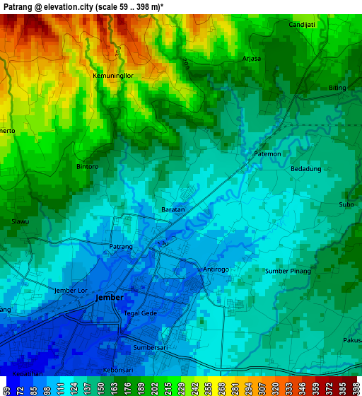
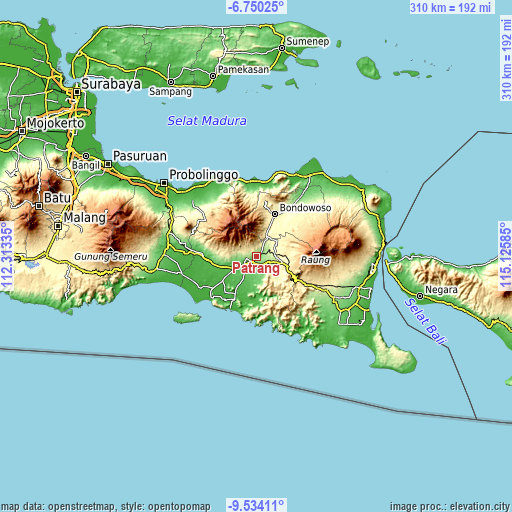
Below is the Elevation map of Patrang, which displays elevation range with different colors. Scale of the first map is from 59 to 398 m (194 to 1306 ft) with average elevation of 159.4 meters (=523 ft) [note 1]
These maps also provides idea of topography and contour of this city, they are displayed at different zoom levels. More info about maps, scale and edge coordinates you can find below images.
| \ | Map #1 | Topo.Map |
| Scale [m] | 59..398 m | × |
| Scale [ft] | 194..1306 ft | × |
| Average | 159.4 m = 523 ft | × |
| Width | 9.67 km = 6 mi | 309.5 km = 192.3 mi |
| Height | 9.67 km = 6 mi | 309.6 km = 192.4 mi |
| ↑Max Latitude | -8.101096° | -6.75025° |
| Latitude at center | -8.1446° | -8.1446° |
| ↓Min Latitude | -8.1881° | -9.53411° |
| ← Min Longitude | 113.675655° | 112.31335° |
| Longitude center | 113.7196° | 113.7196° |
| →Max Longitude | 113.763545° | 115.12585° |
Nearby cities:
Cities around Patrang sort by population:
• Jember elevation 86 m
3.8 km,  215°
215°
• Ledokombo 391 m
17.2 km,  86°
86°
• Sukowono 342 m
15.9 km,  52°
52°
• Jenggawah 57 m
15.6 km,  210°
210°
• Maesan 353 m
14.9 km,  25°
25°
• Rambipuji 54 m
14.1 km,  239°
239°
• Durenan 68 m
13.2 km, 213°
• Glagahwero 89 m
11.7 km,  252°
252°
• Mayang 177 m
9.1 km,  112°
112°
• Jelbuk 254 m
8 km, 32°
• Sukorambi 154 m
6.1 km,  256°
256°
• Kloncing 114 m
4.5 km,  169°
169°
Multilingual:
 En español:
Patrang elevación 113 m.
 En France:
Patrang élévation 113 m.


Sources and notes:
- [note 1] Map square and city borders are not equal. Map elevation data is calculated only from area inside that square.
- [src 1] Elevation data from geonames database provided with same terms of usage.
- [src 2] The elevation map of Patrang is generated using elevation data from NASA's 3 arcsec (90m) resolution SRTM data.
- [src 3] Base (background) map © OpenStreetMap contributors tiles are generated by Geofabrik and OpenTopoMap.
Copyright & License:
This Patrang Elevation Map is licensed under CC BY-SA. You may reuse any part from this page, if you give a proper credit by linking to this URL:
 More info on terms of use page.