Kupang elevation
Kupang (East Nusa Tenggara), Indonesia elevation is 94 meters and Kupang elevation in feet is 308 ft above sea level [src 1]. Kupang is a seat of a first-order administrative division (feature code) with elevation that is 97 meters (318 ft) smaller than average city elevation in Indonesia.
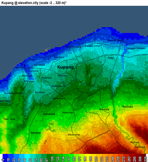
Below is the Elevation map of Kupang, which displays elevation range with different colors. Scale of the first map is from -2 to 320 m (-7 to 1050 ft) with average elevation of 124.5 meters (=408 ft) [note 1]
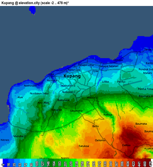
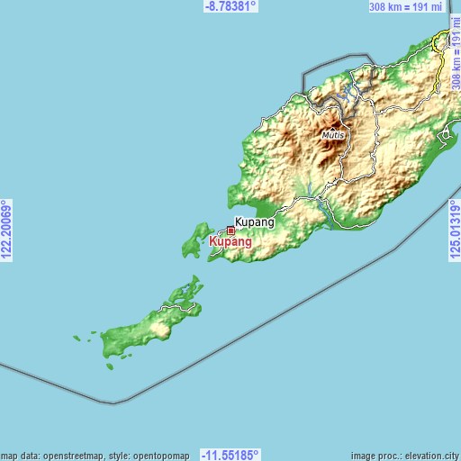
These maps also provides idea of topography and contour of this city, they are displayed at different zoom levels. More info about maps, scale and edge coordinates you can find below images.
| \ | Map #1 | Map #2 | Topo.Map |
| Scale [m] | -2..320 m | -2..478 m | × |
| Scale [ft] | -7..1050 ft | -7..1568 ft | × |
| Average | 124.5 m = 408 ft | 184.2 m = 604 ft | × |
| Width | 9.62 km = 6 mi | 19.24 km = 12 mi | 307.8 km = 191.3 mi |
| Height | 9.62 km = 6 mi | 19.24 km = 12 mi | 307.8 km = 191.3 mi |
| ↑Max Latitude | -10.127572° | -10.084309° | -8.78381° |
| Latitude at center | -10.17083° | -10.17083° | -10.17083° |
| ↓Min Latitude | -10.214082° | -10.257328° | -11.55185° |
| ← Min Longitude | 123.562995° | 123.519049° | 122.20069° |
| Longitude center | 123.60694° | 123.60694° | 123.60694° |
| →Max Longitude | 123.650885° | 123.694831° | 125.01319° |
Nearby cities:
Cities around Kupang sort by population:
• Lelogama elevation 895 m
63.7 km,  36°
36°
• Eahun 51 m
55 km,  206°
206°
• Takari 146 m
53 km,  65°
65°
• Camplong 214 m
37.7 km, 66°
• Oelamasi 50 m
32 km, 68°
• Oekabiti 420 m
24.4 km,  101°
101°
• Uitao 32 m
22 km,  264°
264°
• Babau 18 m
20.9 km, 69°
• Batakte 254 m
10.9 km, 210°
• Tarus 20 m
9.8 km,  64°
64°
• Kelapalima 51 m
2.7 km,  30°
30°
• Oebobo 77 m
0.9 km,  291°
291°
Multilingual:
 En español:
Kupang elevación 94 m.
 En France:
Kupang élévation 94 m.


Sources and notes:
- [note 1] Map square and city borders are not equal. Map elevation data is calculated only from area inside that square.
- [src 1] Elevation data from geonames database provided with same terms of usage.
- [src 2] The elevation map of Kupang is generated using elevation data from NASA's 3 arcsec (90m) resolution SRTM data.
- [src 3] Base (background) map © OpenStreetMap contributors tiles are generated by Geofabrik and OpenTopoMap.
Copyright & License:
This Kupang Elevation Map is licensed under CC BY-SA. You may reuse any part from this page, if you give a proper credit by linking to this URL:
 More info on terms of use page.