Tompasobaru elevation
Tompasobaru (North Sulawesi), Indonesia elevation is 338 meters and Tompasobaru elevation in feet is 1109 ft above sea level [src 1]. Tompasobaru is a seat of a third-order administrative division (feature code) with elevation that is 147 meters (482 ft) bigger than average city elevation in Indonesia.
Below is the Elevation map of Tompasobaru, which displays elevation range with different colors. Scale of the first map is from 246 to 1020 m (807 to 3346 ft) with average elevation of 480.4 meters (=1576 ft) [note 1]
These maps also provides idea of topography and contour of this city, they are displayed at different zoom levels. More info about maps, scale and edge coordinates you can find below images.
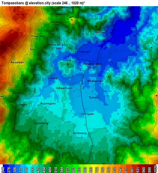
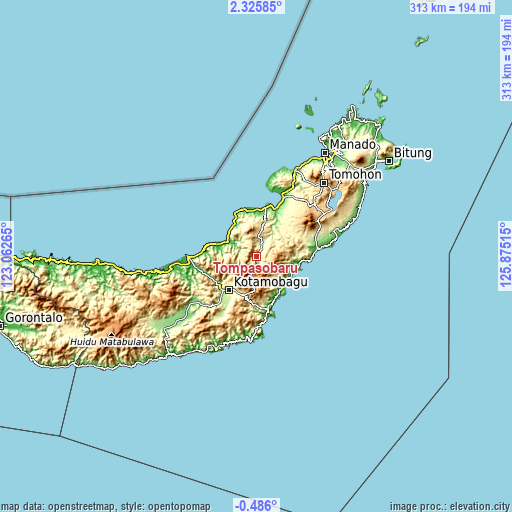
| \ | Map #1 | Topo.Map |
| Scale [m] | 246..1020 m | × |
| Scale [ft] | 807..3346 ft | × |
| Average | 480.4 m = 1576 ft | × |
| Width | 9.77 km = 6.1 mi | 312.6 km = 194.2 mi |
| Height | 9.77 km = 6.1 mi | 312.7 km = 194.3 mi |
| ↑Max Latitude | 0.964139° | 2.32585° |
| Latitude at center | 0.9202° | 0.9202° |
| ↓Min Latitude | 0.87626° | -0.486° |
| ← Min Longitude | 124.424955° | 123.06265° |
| Longitude center | 124.4689° | 124.4689° |
| →Max Longitude | 124.512845° | 125.87515° |
Nearby cities:
Cities around Tompasobaru sort by population:
• Lolayan elevation 216 m
35.4 km,  210°
210°
• Bolaang 5 m
34.9 km,  273°
273°
• Tungoo 329 m
30.1 km,  230°
230°
• Tombatu 391 m
27.4 km,  60°
60°
• Tenga 93 m
27 km,  353°
353°
• Passi 340 m
25.6 km, 227°
• Modayag 528 m
25.2 km,  202°
202°
• Bilalang 378 m
24.8 km, 228°
• Kotabunan 9 m
24 km,  120°
120°
• Tutuyan 10 m
23.6 km,  136°
136°
• Poigar 6 m
22.3 km,  292°
292°
• Poigar 6 m
21 km,  302°
302°
Multilingual:
 En español:
Tompasobaru elevación 338 m.
 En France:
Tompasobaru élévation 338 m.
 Auf Deutsch:
Tompasobaru höhe über dem Meeresspiegel ist 338 m.

Sources and notes:
- [note 1] Map square and city borders are not equal. Map elevation data is calculated only from area inside that square.
- [src 1] Elevation data from geonames database provided with same terms of usage.
- [src 2] The elevation map of Tompasobaru is generated using elevation data from NASA's 3 arcsec (90m) resolution SRTM data.
- [src 3] Base (background) map © OpenStreetMap contributors tiles are generated by Geofabrik and OpenTopoMap.
Copyright & License:
This Tompasobaru Elevation Map is licensed under CC BY-SA. You may reuse any part from this page, if you give a proper credit by linking to this URL:
 More info on terms of use page.