Derecske elevation
Derecske (Hajdú-Bihar), Hungary elevation is 96 meters and Derecske elevation in feet is 315 ft above sea level [src 1]. Derecske is a seat of a second-order administrative division (feature code) with elevation that is 33 meters (108 ft) smaller than average city elevation in Hungary.
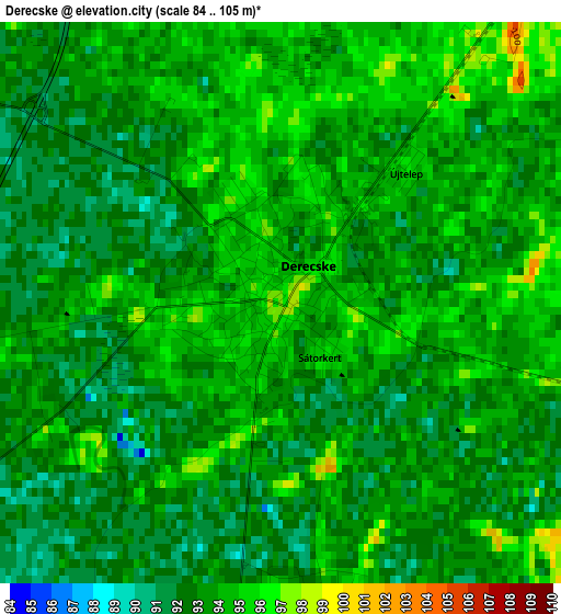
Below is the Elevation map of Derecske, which displays elevation range with different colors. Scale of the first map is from 84 to 105 m (276 to 344 ft) with average elevation of 93.2 meters (=306 ft) [note 1]
These maps also provides idea of topography and contour of this city, they are displayed at different zoom levels. More info about maps, scale and edge coordinates you can find below images.
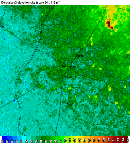
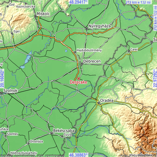
| \ | Map #1 | Map #2 | Topo.Map |
| Scale [m] | 84..105 m | 84..115 m | × |
| Scale [ft] | 276..344 ft | 276..377 ft | × |
| Average | 93.2 m = 306 ft | 93.2 m = 306 ft | × |
| Width | 6.62 km = 4.1 mi | 13.24 km = 8.2 mi | 211.9 km = 131.7 mi |
| Height | 6.62 km = 4.1 mi | 13.24 km = 8.2 mi | 211.9 km = 131.7 mi |
| ↑Max Latitude | 47.379765° | 47.409514° | 48.29417° |
| Latitude at center | 47.35° | 47.35° | 47.35° |
| ↓Min Latitude | 47.320218° | 47.290419° | 46.38863° |
| ← Min Longitude | 21.522725° | 21.478779° | 20.16042° |
| Longitude center | 21.56667° | 21.56667° | 21.56667° |
| →Max Longitude | 21.610615° | 21.654561° | 22.97292° |
Nearby cities:
Cities around Derecske sort by population:
• Hajdúszoboszló elevation 96 m
16.8 km,  311°
311°
• Berettyóújfalu 93 m
14.9 km,  184°
184°
• Hosszúpályi 107 m
13.4 km,  69°
69°
• Ebes 100 m
13.9 km,  338°
338°
• Földes 87 m
16.1 km,  249°
249°
• Mikepércs 104 m
12.2 km,  24°
24°
• Hajdúszovát 88 m
7.3 km,  300°
300°
• Pocsaj 99 m
20.3 km,  111°
111°
• Sáránd 99 m
7.5 km,  42°
42°
• Konyár 95 m
8.4 km,  116°
116°
• Monostorpályi 108 m
17.2 km, 71°
• Hajdúbagos 102 m
8.8 km,  57°
57°
Multilingual:
 En español:
Derecske elevación 96 m.
 En France:
Derecske élévation 96 m.


Sources and notes:
- [note 1] Map square and city borders are not equal. Map elevation data is calculated only from area inside that square.
- [src 1] Elevation data from geonames database provided with same terms of usage.
- [src 2] The elevation map of Derecske is generated using elevation data from NASA's 3 arcsec (90m) resolution SRTM data.
- [src 3] Base (background) map © OpenStreetMap contributors tiles are generated by Geofabrik and OpenTopoMap.
Copyright & License:
This Derecske Elevation Map is licensed under CC BY-SA. You may reuse any part from this page, if you give a proper credit by linking to this URL:
 More info on terms of use page.