Dombrád elevation
Dombrád (Szabolcs-Szatmár-Bereg), Hungary elevation is 96 meters and Dombrád elevation in feet is 315 ft above sea level [src 1]. Dombrád is a populated place (feature code) with elevation that is 33 meters (108 ft) smaller than average city elevation in Hungary.
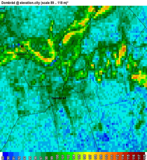
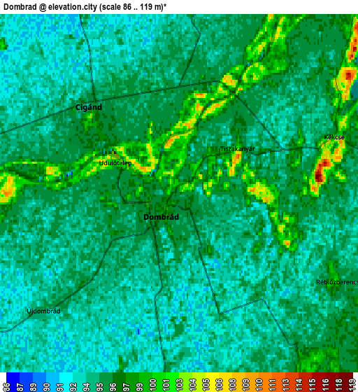
Below is the Elevation map of Dombrád, which displays elevation range with different colors. Scale of the first map is from 89 to 118 m (292 to 387 ft) with average elevation of 96.2 meters (=316 ft) [note 1]
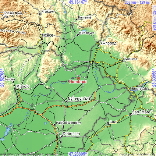
These maps also provides idea of topography and contour of this city, they are displayed at different zoom levels. More info about maps, scale and edge coordinates you can find below images.
| \ | Map #1 | Map #2 | Topo.Map |
| Scale [m] | 89..118 m | 86..119 m | × |
| Scale [ft] | 292..387 ft | 282..390 ft | × |
| Average | 96.2 m = 316 ft | 95.1 m = 312 ft | × |
| Width | 6.51 km = 4 mi | 13.02 km = 8.1 mi | 208.3 km = 129.4 mi |
| Height | 6.51 km = 4 mi | 13.02 km = 8.1 mi | 208.3 km = 129.4 mi |
| ↑Max Latitude | 48.262594° | 48.29184° | 49.16147° |
| Latitude at center | 48.23333° | 48.23333° | 48.23333° |
| ↓Min Latitude | 48.20405° | 48.174753° | 47.28805° |
| ← Min Longitude | 21.889385° | 21.845439° | 20.52708° |
| Longitude center | 21.93333° | 21.93333° | 21.93333° |
| →Max Longitude | 21.977275° | 22.021221° | 23.33958° |
Nearby cities:
Cities around Dombrád sort by population:
• Kisvárda elevation 106 m
11.3 km,  99°
99°
• Demecser 100 m
13 km,  182°
182°
• Ajak 101 m
11.5 km,  123°
123°
• Cigánd 96 m
3.9 km,  308°
308°
• Pátroha 99 m
8.9 km,  146°
146°
• Fényeslitke 104 m
13 km,  71°
71°
• Döge 96 m
10.2 km, 71°
• Gégény 99 m
9.3 km,  172°
172°
• Kék 97 m
13.5 km,  195°
195°
• Anarcs 106 m
14.7 km, 115°
• Karcsa 100 m
12.8 km, 312°
• Ricse 102 m
10.6 km,  15°
15°
Multilingual:
 En español:
Dombrád elevación 96 m.
 En France:
Dombrád élévation 96 m.


Sources and notes:
- [note 1] Map square and city borders are not equal. Map elevation data is calculated only from area inside that square.
- [src 1] Elevation data from geonames database provided with same terms of usage.
- [src 2] The elevation map of Dombrád is generated using elevation data from NASA's 3 arcsec (90m) resolution SRTM data.
- [src 3] Base (background) map © OpenStreetMap contributors tiles are generated by Geofabrik and OpenTopoMap.
Copyright & License:
This Dombrád Elevation Map is licensed under CC BY-SA. You may reuse any part from this page, if you give a proper credit by linking to this URL:
 More info on terms of use page.