Karácsond elevation
Karácsond (Heves), Hungary elevation is 120 meters and Karácsond elevation in feet is 394 ft above sea level [src 1]. Karácsond is a populated place (feature code) with elevation that is 9 meters (30 ft) smaller than average city elevation in Hungary.
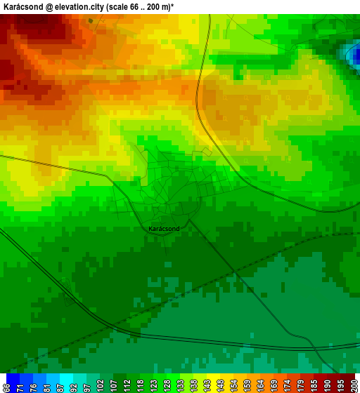
Below is the Elevation map of Karácsond, which displays elevation range with different colors. Scale of the first map is from 66 to 200 m (217 to 656 ft) with average elevation of 128.7 meters (=422 ft) [note 1]
These maps also provides idea of topography and contour of this city, they are displayed at different zoom levels. More info about maps, scale and edge coordinates you can find below images.
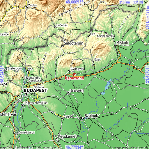
| \ | Map #1 | Topo.Map |
| Scale [m] | 66..200 m | × |
| Scale [ft] | 217..656 ft | × |
| Average | 128.7 m = 422 ft | × |
| Width | 6.57 km = 4.1 mi | 210.3 km = 130.7 mi |
| Height | 6.57 km = 4.1 mi | 210.3 km = 130.7 mi |
| ↑Max Latitude | 47.759171° | 48.66693° |
| Latitude at center | 47.72962° | 47.72962° |
| ↓Min Latitude | 47.700053° | 46.77514° |
| ← Min Longitude | 19.986815° | 18.62451° |
| Longitude center | 20.03076° | 20.03076° |
| →Max Longitude | 20.074705° | 21.43701° |
Nearby cities:
Cities around Karácsond sort by population:
• Gyöngyös elevation 168 m
9.7 km,  307°
307°
• Jászárokszállás 101 m
10.4 km,  201°
201°
• Nagyréde 133 m
14.2 km,  286°
286°
• Abasár 175 m
7.8 km,  344°
344°
• Gyöngyössolymos 238 m
12 km,  324°
324°
• Adács 111 m
5.8 km,  223°
223°
• Gyöngyöshalász 131 m
7.7 km,  279°
279°
• Gyöngyöstarján 198 m
15.4 km, 307°
• Kompolt 114 m
16.4 km,  88°
88°
• Domoszló 192 m
13.2 km,  29°
29°
• Vámosgyörk 106 m
9.1 km,  236°
236°
• Tarnaörs 94 m
15.1 km,  173°
173°
Multilingual:
 En español:
Karácsond elevación 120 m.
 En France:
Karácsond élévation 120 m.
 Auf Deutsch:
Karácsond höhe über dem Meeresspiegel ist 120 m.

Sources and notes:
- [note 1] Map square and city borders are not equal. Map elevation data is calculated only from area inside that square.
- [src 1] Elevation data from geonames database provided with same terms of usage.
- [src 2] The elevation map of Karácsond is generated using elevation data from NASA's 3 arcsec (90m) resolution SRTM data.
- [src 3] Base (background) map © OpenStreetMap contributors tiles are generated by Geofabrik and OpenTopoMap.
Copyright & License:
This Karácsond Elevation Map is licensed under CC BY-SA. You may reuse any part from this page, if you give a proper credit by linking to this URL:
 More info on terms of use page.