Szegvár elevation
Szegvár (Csongrád), Hungary elevation is 82 meters and Szegvár elevation in feet is 269 ft above sea level [src 1]. Szegvár is a populated place (feature code) with elevation that is 47 meters (154 ft) smaller than average city elevation in Hungary.
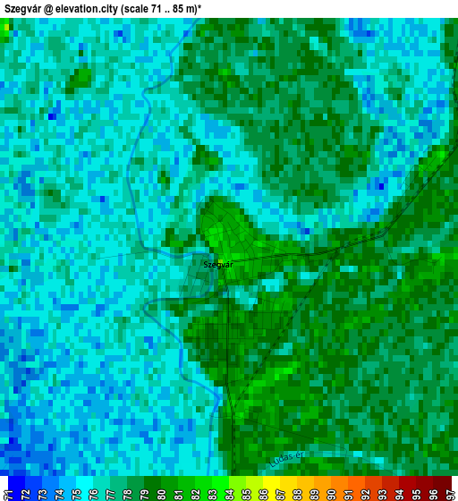
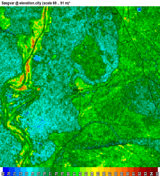
Below is the Elevation map of Szegvár, which displays elevation range with different colors. Scale of the first map is from 71 to 85 m (233 to 279 ft) with average elevation of 76.7 meters (=252 ft) [note 1]
These maps also provides idea of topography and contour of this city, they are displayed at different zoom levels. More info about maps, scale and edge coordinates you can find below images.
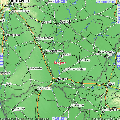
| \ | Map #1 | Map #2 | Topo.Map |
| Scale [m] | 71..85 m | 69..91 m | × |
| Scale [ft] | 233..279 ft | 226..299 ft | × |
| Average | 76.7 m = 252 ft | 77.3 m = 254 ft | × |
| Width | 6.72 km = 4.2 mi | 13.43 km = 8.3 mi | 214.9 km = 133.5 mi |
| Height | 6.72 km = 4.2 mi | 13.43 km = 8.3 mi | 214.9 km = 133.5 mi |
| ↑Max Latitude | 46.617593° | 46.647769° | 47.54523° |
| Latitude at center | 46.5874° | 46.5874° | 46.5874° |
| ↓Min Latitude | 46.55719° | 46.526964° | 45.61234° |
| ← Min Longitude | 20.180135° | 20.136189° | 18.81783° |
| Longitude center | 20.22408° | 20.22408° | 20.22408° |
| →Max Longitude | 20.268025° | 20.311971° | 21.63033° |
Nearby cities:
Cities around Szegvár sort by population:
• Hódmezővásárhely elevation 80 m
20.7 km,  156°
156°
• Csongrád 81 m
15.3 km,  336°
336°
• Kistelek 88 m
22.6 km,  235°
235°
• Mindszent 80 m
7.5 km,  199°
199°
• Csanytelek 79 m
7.7 km,  276°
276°
• Baks 80 m
10.6 km, 242°
• Fábiánsebestyén 79 m
21.4 km,  60°
60°
• Ópusztaszer 81 m
15.4 km,  222°
222°
• Pálmonostora 85 m
21.2 km, 281°
• Tömörkény 82 m
14.2 km, 283°
• Pusztaszer 83 m
18.5 km,  257°
257°
• Szentes 80 m
8.4 km,  19°
19°
Multilingual:
 En español:
Szegvár elevación 82 m.
 En France:
Szegvár élévation 82 m.


Sources and notes:
- [note 1] Map square and city borders are not equal. Map elevation data is calculated only from area inside that square.
- [src 1] Elevation data from geonames database provided with same terms of usage.
- [src 2] The elevation map of Szegvár is generated using elevation data from NASA's 3 arcsec (90m) resolution SRTM data.
- [src 3] Base (background) map © OpenStreetMap contributors tiles are generated by Geofabrik and OpenTopoMap.
Copyright & License:
This Szegvár Elevation Map is licensed under CC BY-SA. You may reuse any part from this page, if you give a proper credit by linking to this URL:
 More info on terms of use page.