Tiszalúc elevation
Tiszalúc (Borsod-Abaúj-Zemplén), Hungary elevation is 106 meters and Tiszalúc elevation in feet is 348 ft above sea level [src 1]. Tiszalúc is a populated place (feature code) with elevation that is 23 meters (75 ft) smaller than average city elevation in Hungary.
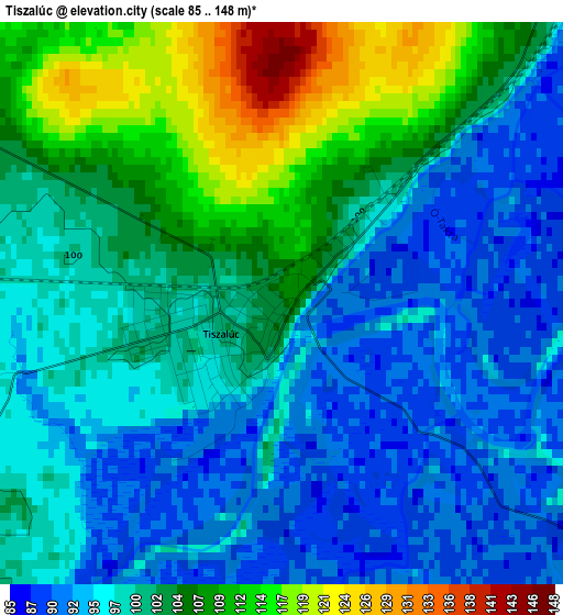
Below is the Elevation map of Tiszalúc, which displays elevation range with different colors. Scale of the first map is from 85 to 148 m (279 to 486 ft) with average elevation of 100.3 meters (=329 ft) [note 1]
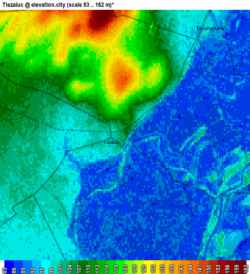
These maps also provides idea of topography and contour of this city, they are displayed at different zoom levels. More info about maps, scale and edge coordinates you can find below images.
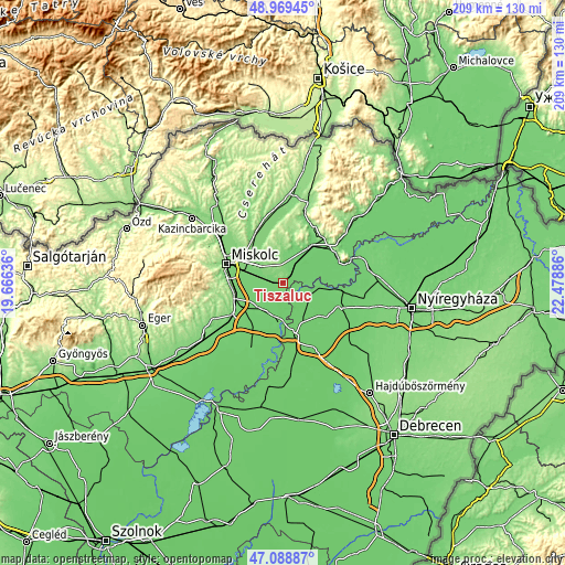
| \ | Map #1 | Map #2 | Topo.Map |
| Scale [m] | 85..148 m | 83..162 m | × |
| Scale [ft] | 279..486 ft | 272..531 ft | × |
| Average | 100.3 m = 329 ft | 101.4 m = 333 ft | × |
| Width | 6.53 km = 4.1 mi | 13.07 km = 8.1 mi | 209.1 km = 129.9 mi |
| Height | 6.53 km = 4.1 mi | 13.07 km = 8.1 mi | 209.1 km = 129.9 mi |
| ↑Max Latitude | 48.067115° | 48.096474° | 48.96945° |
| Latitude at center | 48.03774° | 48.03774° | 48.03774° |
| ↓Min Latitude | 48.008348° | 47.978939° | 47.08887° |
| ← Min Longitude | 21.028665° | 20.984719° | 19.66636° |
| Longitude center | 21.07261° | 21.07261° | 21.07261° |
| →Max Longitude | 21.116555° | 21.160501° | 22.47886° |
Nearby cities:
Cities around Tiszalúc sort by population:
• Tiszaújváros elevation 89 m
11.6 km,  176°
176°
• Taktaharkány 93 m
6.8 km,  41°
41°
• Hernádnémeti 111 m
7.4 km,  295°
295°
• Tiszadob 90 m
7.4 km,  108°
108°
• Sajólád 104 m
12.9 km,  276°
276°
• Gesztely 113 m
10.5 km,  311°
311°
• Bőcs 102 m
8 km, 279°
• Tiszadada 95 m
13.2 km,  92°
92°
• Ónod 102 m
12.3 km,  250°
250°
• Sajószöged 93 m
11.2 km,  208°
208°
• Taktaszada 95 m
12 km, 43°
• Sajóörös 93 m
10.2 km,  196°
196°
Multilingual:
 En español:
Tiszalúc elevación 106 m.
 En France:
Tiszalúc élévation 106 m.
 Auf Deutsch:
Tiszalúc höhe über dem Meeresspiegel ist 106 m.

Sources and notes:
- [note 1] Map square and city borders are not equal. Map elevation data is calculated only from area inside that square.
- [src 1] Elevation data from geonames database provided with same terms of usage.
- [src 2] The elevation map of Tiszalúc is generated using elevation data from NASA's 3 arcsec (90m) resolution SRTM data.
- [src 3] Base (background) map © OpenStreetMap contributors tiles are generated by Geofabrik and OpenTopoMap.
Copyright & License:
This Tiszalúc Elevation Map is licensed under CC BY-SA. You may reuse any part from this page, if you give a proper credit by linking to this URL:
 More info on terms of use page.