Tótkomlós elevation
Tótkomlós (Bekes), Hungary elevation is 91 meters and Tótkomlós elevation in feet is 299 ft above sea level [src 1]. Tótkomlós is a populated place (feature code) with elevation that is 38 meters (125 ft) smaller than average city elevation in Hungary.
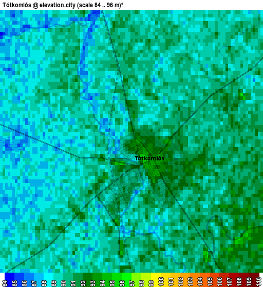
Below is the Elevation map of Tótkomlós, which displays elevation range with different colors. Scale of the first map is from 84 to 96 m (276 to 315 ft) with average elevation of 89.4 meters (=293 ft) [note 1]
These maps also provides idea of topography and contour of this city, they are displayed at different zoom levels. More info about maps, scale and edge coordinates you can find below images.
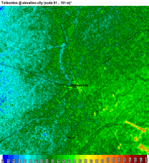
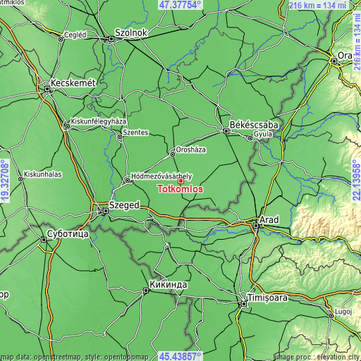
| \ | Map #1 | Map #2 | Topo.Map |
| Scale [m] | 84..96 m | 81..101 m | × |
| Scale [ft] | 276..315 ft | 266..331 ft | × |
| Average | 89.4 m = 293 ft | 88.9 m = 292 ft | × |
| Width | 6.74 km = 4.2 mi | 13.47 km = 8.4 mi | 215.6 km = 134 mi |
| Height | 6.74 km = 4.2 mi | 13.47 km = 8.4 mi | 215.6 km = 134 mi |
| ↑Max Latitude | 46.446958° | 46.477229° | 47.37754° |
| Latitude at center | 46.41667° | 46.41667° | 46.41667° |
| ↓Min Latitude | 46.386365° | 46.356044° | 45.43857° |
| ← Min Longitude | 20.689385° | 20.645439° | 19.32708° |
| Longitude center | 20.73333° | 20.73333° | 20.73333° |
| →Max Longitude | 20.777275° | 20.821221° | 22.13958° |
Nearby cities:
Cities around Tótkomlós sort by population:
• Orosháza elevation 88 m
17.4 km,  342°
342°
• Mezőkovácsháza 97 m
14.2 km,  97°
97°
• Mezőhegyes 96 m
12.8 km,  150°
150°
• Földeák 81 m
21.1 km,  238°
238°
• Csanádpalota 86 m
18.5 km,  180°
180°
• Kunágota 94 m
24.3 km,  85°
85°
• Csanádapáca 90 m
18.8 km,  37°
37°
• Magyarbánhegyes 92 m
18.3 km,  78°
78°
• Székkutas 83 m
17.9 km,  301°
301°
• Békéssámson 85 m
7.7 km,  270°
270°
• Kaszaper 90 m
9.5 km,  54°
54°
• Pusztaföldvár 88 m
13.9 km,  21°
21°
Multilingual:
 En español:
Tótkomlós elevación 91 m.
 En France:
Tótkomlós élévation 91 m.
 Auf Deutsch:
Tótkomlós höhe über dem Meeresspiegel ist 91 m.

Sources and notes:
- [note 1] Map square and city borders are not equal. Map elevation data is calculated only from area inside that square.
- [src 1] Elevation data from geonames database provided with same terms of usage.
- [src 2] The elevation map of Tótkomlós is generated using elevation data from NASA's 3 arcsec (90m) resolution SRTM data.
- [src 3] Base (background) map © OpenStreetMap contributors tiles are generated by Geofabrik and OpenTopoMap.
Copyright & License:
This Tótkomlós Elevation Map is licensed under CC BY-SA. You may reuse any part from this page, if you give a proper credit by linking to this URL:
 More info on terms of use page.