Erzsébetváros elevation
Erzsébetváros (Budapest), Hungary elevation is 114 meters and Erzsébetváros elevation in feet is 374 ft above sea level [src 1]. Erzsébetváros is a section of populated place (feature code) with elevation that is 15 meters (49 ft) smaller than average city elevation in Hungary.
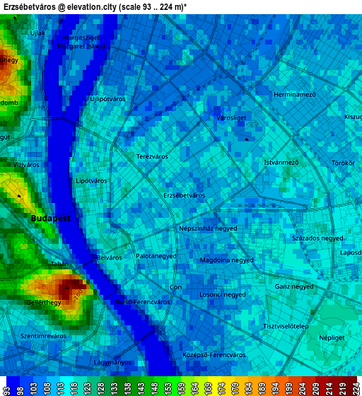
Below is the Elevation map of Erzsébetváros, which displays elevation range with different colors. Scale of the first map is from 93 to 224 m (305 to 735 ft) with average elevation of 114.7 meters (=376 ft) [note 1]
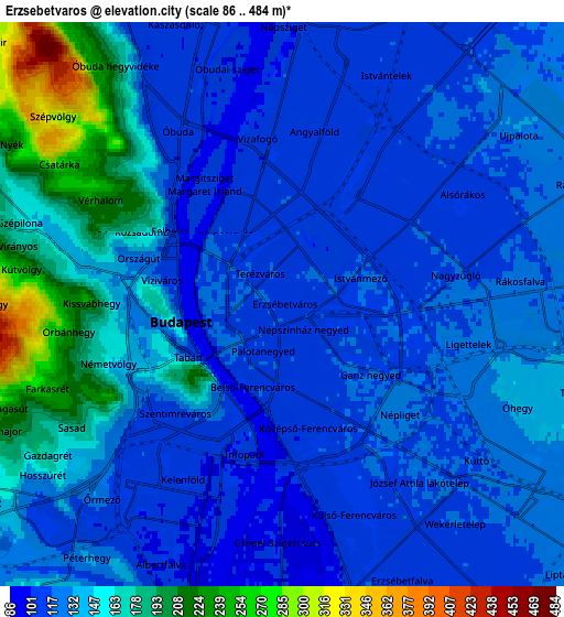
These maps also provides idea of topography and contour of this city, they are displayed at different zoom levels. More info about maps, scale and edge coordinates you can find below images.
| \ | Map #1 | Map #2 | Topo.Map |
| Scale [m] | 93..224 m | 86..484 m | × |
| Scale [ft] | 305..735 ft | 282..1588 ft | × |
| Average | 114.7 m = 376 ft | 136.7 m = 448 ft | × |
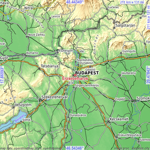
| Width | 6.6 km = 4.1 mi | 13.2 km = 8.2 mi | 211.3 km = 131.3 mi |
| Height | 6.6 km = 4.1 mi | 13.2 km = 8.2 mi | 211.3 km = 131.3 mi |
| ↑Max Latitude | 47.531749° | 47.561412° | 48.44349° |
| Latitude at center | 47.50207° | 47.50207° | 47.50207° |
| ↓Min Latitude | 47.472374° | 47.442661° | 46.54346° |
| ← Min Longitude | 19.028235° | 18.984289° | 17.66593° |
| Longitude center | 19.07218° | 19.07218° | 19.07218° |
| →Max Longitude | 19.116125° | 19.160071° | 20.47843° |
Nearby cities:
Cities around Erzsébetváros sort by population:
• Budapest elevation 75 m
2.4 km,  260°
260°
• Budapest XI. kerület 107 m
4 km,  223°
223°
• Zugló 111 m
3 km,  55°
55°
• Budapest III. kerület 109 m
4.8 km,  335°
335°
• Budapest XIII. kerület 106 m
3.1 km,  11°
11°
• Budapest IV. kerület 109 m
6.8 km, 10°
• Budapest II. kerület 202 m
4.2 km,  297°
297°
• Budapest VIII. kerület 115 m
1.4 km,  186°
186°
• Józsefváros 110 m
1.4 km,  177°
177°
• Budapest XII. kerület 168 m
4.4 km, 255°
• Budapest VI. kerület 117 m
0.5 km,  290°
290°
• Budapest I. kerület 150 m
2.5 km, 257°
Multilingual:
 En español:
Erzsébetváros elevación 114 m.
 En France:
7e arrondissement de Budapest élévation 114 m.
 Auf Deutsch:
VII. Budapester Bezirk höhe über dem Meeresspiegel ist 114 m.

Sources and notes:
- [note 1] Map square and city borders are not equal. Map elevation data is calculated only from area inside that square.
- [src 1] Elevation data from geonames database provided with same terms of usage.
- [src 2] The elevation map of Erzsébetváros is generated using elevation data from NASA's 3 arcsec (90m) resolution SRTM data.
- [src 3] Base (background) map © OpenStreetMap contributors tiles are generated by Geofabrik and OpenTopoMap.
Copyright & License:
This Erzsébetváros Elevation Map is licensed under CC BY-SA. You may reuse any part from this page, if you give a proper credit by linking to this URL:
 More info on terms of use page.