Kecskemét elevation
Kecskemét (Bács-Kiskun), Hungary elevation is 120 meters and Kecskemét elevation in feet is 394 ft above sea level [src 1]. Kecskemét is a seat of a first-order administrative division (feature code) with elevation that is 9 meters (30 ft) smaller than average city elevation in Hungary.
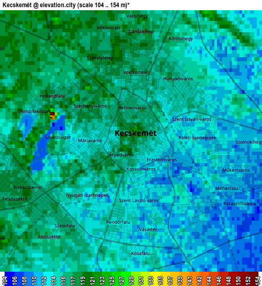
Below is the Elevation map of Kecskemét, which displays elevation range with different colors. Scale of the first map is from 104 to 154 m (341 to 505 ft) with average elevation of 114.4 meters (=375 ft) [note 1]
These maps also provides idea of topography and contour of this city, they are displayed at different zoom levels. More info about maps, scale and edge coordinates you can find below images.

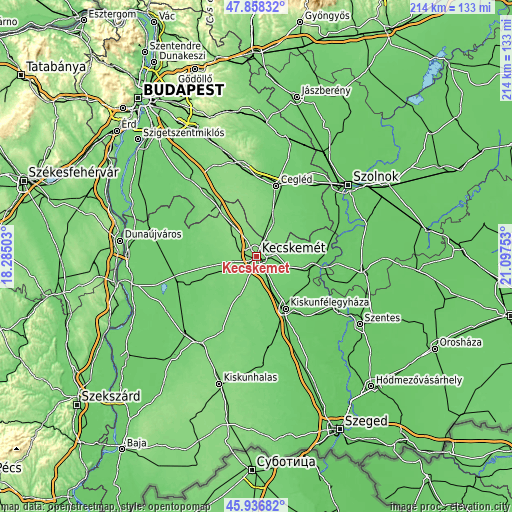
| \ | Map #1 | Map #2 | Topo.Map |
| Scale [m] | 104..154 m | 100..154 m | × |
| Scale [ft] | 341..505 ft | 328..505 ft | × |
| Average | 114.4 m = 375 ft | 114.7 m = 376 ft | × |
| Width | 6.68 km = 4.2 mi | 13.35 km = 8.3 mi | 213.7 km = 132.8 mi |
| Height | 6.68 km = 4.2 mi | 13.35 km = 8.3 mi | 213.6 km = 132.7 mi |
| ↑Max Latitude | 46.936195° | 46.966193° | 47.85832° |
| Latitude at center | 46.90618° | 46.90618° | 46.90618° |
| ↓Min Latitude | 46.876148° | 46.8461° | 45.93682° |
| ← Min Longitude | 19.647335° | 19.603389° | 18.28503° |
| Longitude center | 19.69128° | 19.69128° | 19.69128° |
| →Max Longitude | 19.735225° | 19.779171° | 21.09753° |
Nearby cities:
Cities around Kecskemét sort by population:
• Nagykőrös elevation 113 m
15.7 km,  24°
24°
• Lajosmizse 132 m
16.1 km,  322°
322°
• Kerekegyháza 118 m
16.6 km,  282°
282°
• Lakitelek 92 m
23.3 km,  98°
98°
• Helvécia 121 m
9.3 km,  214°
214°
• Ballószög 121 m
10.4 km,  241°
241°
• Nyárlőrinc 102 m
15.1 km,  109°
109°
• Városföld 108 m
11.1 km,  153°
153°
• Kocsér 100 m
20.4 km,  58°
58°
• Szentkirály 101 m
17.3 km,  85°
85°
• Ágasegyháza 105 m
19.6 km,  248°
248°
• Fülöpjakab 112 m
18.4 km,  172°
172°
Multilingual:
 En español:
Kecskemét elevación 120 m.
 En France:
Kecskemét élévation 120 m.
 Auf Deutsch:
Kecskemét, Kecskemet höhe über dem Meeresspiegel ist 120 m.

Sources and notes:
- [note 1] Map square and city borders are not equal. Map elevation data is calculated only from area inside that square.
- [src 1] Elevation data from geonames database provided with same terms of usage.
- [src 2] The elevation map of Kecskemét is generated using elevation data from NASA's 3 arcsec (90m) resolution SRTM data.
- [src 3] Base (background) map © OpenStreetMap contributors tiles are generated by Geofabrik and OpenTopoMap.
Copyright & License:
This Kecskemét Elevation Map is licensed under CC BY-SA. You may reuse any part from this page, if you give a proper credit by linking to this URL:
 More info on terms of use page.