Őrbottyán elevation
Őrbottyán (Pest), Hungary elevation is 187 meters and Őrbottyán elevation in feet is 614 ft above sea level [src 1]. Őrbottyán is a populated place (feature code) with elevation that is 58 meters (190 ft) bigger than average city elevation in Hungary.
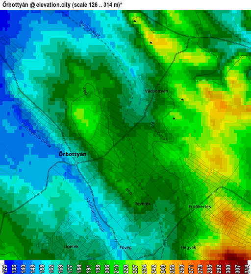
Below is the Elevation map of Őrbottyán, which displays elevation range with different colors. Scale of the first map is from 126 to 314 m (413 to 1030 ft) with average elevation of 187.3 meters (=615 ft) [note 1]
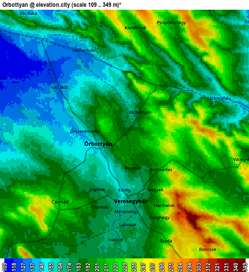
These maps also provides idea of topography and contour of this city, they are displayed at different zoom levels. More info about maps, scale and edge coordinates you can find below images.
| \ | Map #1 | Map #2 | Topo.Map |
| Scale [m] | 126..314 m | 109..349 m | × |
| Scale [ft] | 413..1030 ft | 358..1145 ft | × |
| Average | 187.3 m = 615 ft | 190.5 m = 625 ft | × |
| Width | 6.58 km = 4.1 mi | 13.16 km = 8.2 mi | 210.5 km = 130.8 mi |
| Height | 6.58 km = 4.1 mi | 13.16 km = 8.2 mi | 210.5 km = 130.8 mi |
| ↑Max Latitude | 47.716685° | 47.746243° | 48.62519° |
| Latitude at center | 47.68711° | 47.68711° | 47.68711° |
| ↓Min Latitude | 47.657519° | 47.62791° | 46.73185° |
| ← Min Longitude | 19.238445° | 19.194499° | 17.87614° |
| Longitude center | 19.28239° | 19.28239° | 19.28239° |
| →Max Longitude | 19.326335° | 19.370281° | 20.68864° |
Nearby cities:
Cities around Őrbottyán sort by population:
• Gödöllő elevation 210 m
11.4 km,  151°
151°
• Fót 145 m
10.4 km,  222°
222°
• Göd 112 m
11.1 km,  267°
267°
• Veresegyház 175 m
4.7 km,  168°
168°
• Erdőkertes 210 m
2.5 km,  130°
130°
• Mogyoród 188 m
10.4 km,  197°
197°
• Sződliget 113 m
11.3 km,  296°
296°
• Szada 247 m
6.5 km,  156°
156°
• Sződ 110 m
9.3 km, 296°
• Iklad 140 m
11.8 km,  101°
101°
• Galgamácsa 146 m
7.9 km,  83°
83°
• Domony 131 m
11.8 km,  107°
107°
Multilingual:
 En español:
Őrbottyán elevación 187 m.
 En France:
Őrbottyán élévation 187 m.
 Auf Deutsch:
Őrbottyán höhe über dem Meeresspiegel ist 187 m.

Sources and notes:
- [note 1] Map square and city borders are not equal. Map elevation data is calculated only from area inside that square.
- [src 1] Elevation data from geonames database provided with same terms of usage.
- [src 2] The elevation map of Őrbottyán is generated using elevation data from NASA's 3 arcsec (90m) resolution SRTM data.
- [src 3] Base (background) map © OpenStreetMap contributors tiles are generated by Geofabrik and OpenTopoMap.
Copyright & License:
This Őrbottyán Elevation Map is licensed under CC BY-SA. You may reuse any part from this page, if you give a proper credit by linking to this URL:
 More info on terms of use page.