Salgótarján elevation
Salgótarján (Nógrád), Hungary elevation is 242 meters and Salgótarján elevation in feet is 794 ft above sea level [src 1]. Salgótarján is a seat of a first-order administrative division (feature code) with elevation that is 113 meters (371 ft) bigger than average city elevation in Hungary.
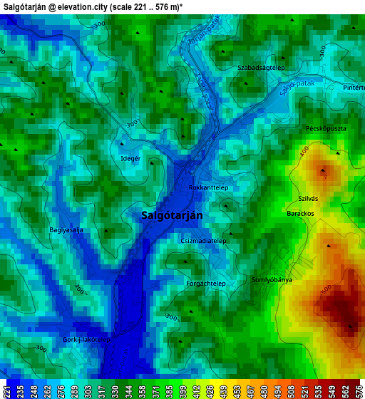
Below is the Elevation map of Salgótarján, which displays elevation range with different colors. Scale of the first map is from 221 to 576 m (725 to 1890 ft) with average elevation of 320.3 meters (=1051 ft) [note 1]
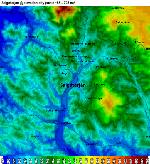
These maps also provides idea of topography and contour of this city, they are displayed at different zoom levels. More info about maps, scale and edge coordinates you can find below images.
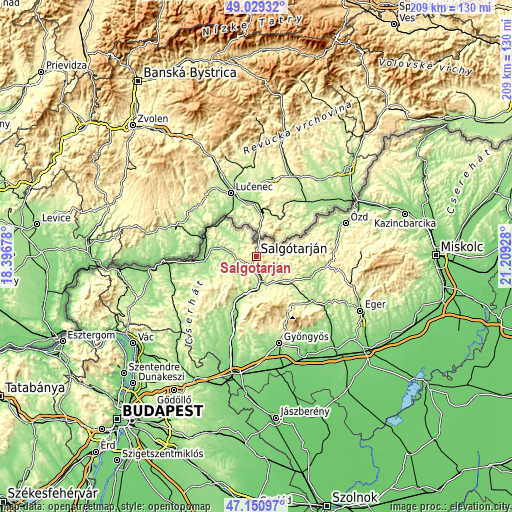
| \ | Map #1 | Map #2 | Topo.Map |
| Scale [m] | 221..576 m | 188..705 m | × |
| Scale [ft] | 725..1890 ft | 617..2313 ft | × |
| Average | 320.3 m = 1051 ft | 319.8 m = 1049 ft | × |
| Width | 6.53 km = 4.1 mi | 13.05 km = 8.1 mi | 208.9 km = 129.8 mi |
| Height | 6.53 km = 4.1 mi | 13.05 km = 8.1 mi | 208.8 km = 129.7 mi |
| ↑Max Latitude | 48.12806° | 48.157384° | 49.02932° |
| Latitude at center | 48.09872° | 48.09872° | 48.09872° |
| ↓Min Latitude | 48.069363° | 48.039989° | 47.15097° |
| ← Min Longitude | 19.759085° | 19.715139° | 18.39678° |
| Longitude center | 19.80303° | 19.80303° | 19.80303° |
| →Max Longitude | 19.846975° | 19.890921° | 21.20928° |
Nearby cities:
Cities around Salgótarján sort by population:
• Bátonyterenye elevation 223 m
14.6 km,  168°
168°
• Pásztó 168 m
21.3 km,  201°
201°
• Szécsény 172 m
21.1 km,  264°
264°
• Karancslapujtő 199 m
7.7 km,  317°
317°
• Somoskőújfalu 310 m
7.4 km,  11°
11°
• Mátraverebély 178 m
13.9 km,  186°
186°
• Kazár 235 m
7 km,  141°
141°
• Mátraterenye 228 m
13 km,  124°
124°
• Tar 171 m
16.7 km, 194°
• Mátranovák 237 m
14.9 km, 116°
• Karancskeszi 184 m
10.7 km,  312°
312°
• Rimóc 178 m
21.4 km,  251°
251°
Multilingual:
 En español:
Salgótarján elevación 242 m.
 En France:
Salgótarján élévation 242 m.
 Auf Deutsch:
Schalgau höhe über dem Meeresspiegel ist 242 m.

Sources and notes:
- [note 1] Map square and city borders are not equal. Map elevation data is calculated only from area inside that square.
- [src 1] Elevation data from geonames database provided with same terms of usage.
- [src 2] The elevation map of Salgótarján is generated using elevation data from NASA's 3 arcsec (90m) resolution SRTM data.
- [src 3] Base (background) map © OpenStreetMap contributors tiles are generated by Geofabrik and OpenTopoMap.
Copyright & License:
This Salgótarján Elevation Map is licensed under CC BY-SA. You may reuse any part from this page, if you give a proper credit by linking to this URL:
 More info on terms of use page.