Tokod elevation
Tokod (Komárom-Esztergom), Hungary elevation is 120 meters and Tokod elevation in feet is 394 ft above sea level [src 1]. Tokod is a populated place (feature code) with elevation that is 9 meters (30 ft) smaller than average city elevation in Hungary.
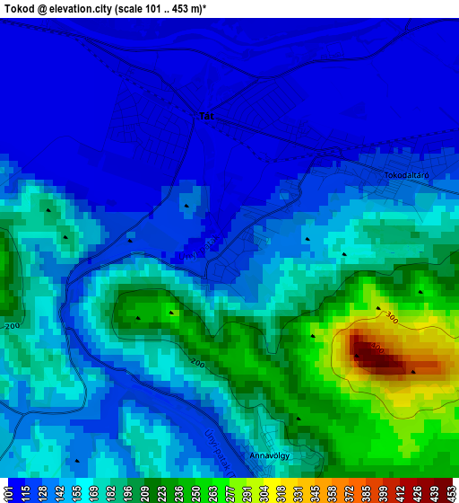
Below is the Elevation map of Tokod, which displays elevation range with different colors. Scale of the first map is from 101 to 453 m (331 to 1486 ft) with average elevation of 158.6 meters (=520 ft) [note 1]
These maps also provides idea of topography and contour of this city, they are displayed at different zoom levels. More info about maps, scale and edge coordinates you can find below images.
| \ | Map #1 | Map #2 | Topo.Map |
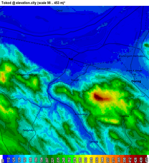
| Scale [m] | 101..453 m | 98..453 m | × |
| Scale [ft] | 331..1486 ft | 322..1486 ft | × |
| Average | 158.6 m = 520 ft | 159.4 m = 523 ft | × |
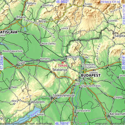
| Width | 6.57 km = 4.1 mi | 13.15 km = 8.2 mi | 210.4 km = 130.7 mi |
| Height | 6.57 km = 4.1 mi | 13.15 km = 8.2 mi | 210.4 km = 130.7 mi |
| ↑Max Latitude | 47.752324° | 47.781862° | 48.6602° |
| Latitude at center | 47.72277° | 47.72277° | 47.72277° |
| ↓Min Latitude | 47.693199° | 47.663611° | 46.76816° |
| ← Min Longitude | 18.614945° | 18.570999° | 17.25264° |
| Longitude center | 18.65889° | 18.65889° | 18.65889° |
| →Max Longitude | 18.702835° | 18.746781° | 20.06514° |
Nearby cities:
Cities around Tokod sort by population:
• Esztergom elevation 110 m
9.9 km,  38°
38°
• Dorog 129 m
5.8 km,  91°
91°
• Nyergesújfalu 108 m
8.7 km,  298°
298°
• Piliscsaba 211 m
16.1 km,  127°
127°
• Tát 106 m
2.2 km,  338°
338°
• Lábatlan 143 m
12.5 km,  282°
282°
• Csolnok 209 m
5.5 km, 129°
• Sárisáp 130 m
5.3 km,  163°
163°
• Kesztölc 204 m
10.7 km,  96°
96°
• Piliscsév 186 m
12.9 km,  112°
112°
• Bajna 199 m
8.9 km,  211°
211°
• Süttő 116 m
16.2 km, 284°
Multilingual:
 En español:
Tokod elevación 120 m.
 En France:
Tokod élévation 120 m.


Sources and notes:
- [note 1] Map square and city borders are not equal. Map elevation data is calculated only from area inside that square.
- [src 1] Elevation data from geonames database provided with same terms of usage.
- [src 2] The elevation map of Tokod is generated using elevation data from NASA's 3 arcsec (90m) resolution SRTM data.
- [src 3] Base (background) map © OpenStreetMap contributors tiles are generated by Geofabrik and OpenTopoMap.
Copyright & License:
This Tokod Elevation Map is licensed under CC BY-SA. You may reuse any part from this page, if you give a proper credit by linking to this URL:
 More info on terms of use page.