Vaskút elevation
Vaskút (Bács-Kiskun), Hungary elevation is 101 meters and Vaskút elevation in feet is 331 ft above sea level [src 1]. Vaskút is a populated place (feature code) with elevation that is 28 meters (92 ft) smaller than average city elevation in Hungary.
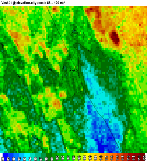
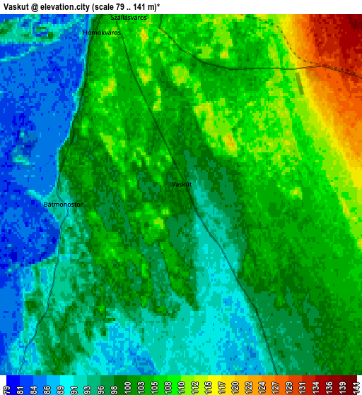
Below is the Elevation map of Vaskút, which displays elevation range with different colors. Scale of the first map is from 88 to 120 m (289 to 394 ft) with average elevation of 101.5 meters (=333 ft) [note 1]
These maps also provides idea of topography and contour of this city, they are displayed at different zoom levels. More info about maps, scale and edge coordinates you can find below images.
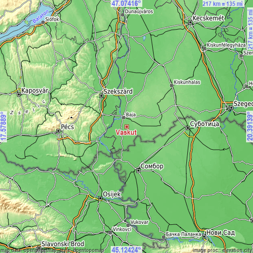
| \ | Map #1 | Map #2 | Topo.Map |
| Scale [m] | 88..120 m | 79..141 m | × |
| Scale [ft] | 289..394 ft | 259..463 ft | × |
| Average | 101.5 m = 333 ft | 99.9 m = 328 ft | × |
| Width | 6.78 km = 4.2 mi | 13.55 km = 8.4 mi | 216.8 km = 134.7 mi |
| Height | 6.78 km = 4.2 mi | 13.55 km = 8.4 mi | 216.8 km = 134.7 mi |
| ↑Max Latitude | 46.138279° | 46.168721° | 47.07416° |
| Latitude at center | 46.10782° | 46.10782° | 46.10782° |
| ↓Min Latitude | 46.077344° | 46.046851° | 45.12424° |
| ← Min Longitude | 18.941195° | 18.897249° | 17.57889° |
| Longitude center | 18.98514° | 18.98514° | 18.98514° |
| →Max Longitude | 19.029085° | 19.073031° | 20.39139° |
Nearby cities:
Cities around Vaskút sort by population:
• Baja elevation 99 m
8.7 km,  343°
343°
• Bácsbokod 115 m
13.3 km,  81°
81°
• Érsekcsanád 96 m
16.2 km,  359°
359°
• Gara 95 m
9.5 km,  152°
152°
• Nagybaracska 90 m
9.5 km,  220°
220°
• Katymár 103 m
19.1 km,  115°
115°
• Hercegszántó 87 m
17.9 km,  191°
191°
• Dávod 87 m
13.6 km,  202°
202°
• Dunaszekcső 99 m
17.6 km,  262°
262°
• Csávoly 130 m
15.4 km,  53°
53°
• Felsőszentiván 127 m
18.4 km,  57°
57°
• Báta 85 m
16.7 km,  277°
277°
Multilingual:
 En español:
Vaskút elevación 101 m.
 En France:
Vaskút élévation 101 m.


Sources and notes:
- [note 1] Map square and city borders are not equal. Map elevation data is calculated only from area inside that square.
- [src 1] Elevation data from geonames database provided with same terms of usage.
- [src 2] The elevation map of Vaskút is generated using elevation data from NASA's 3 arcsec (90m) resolution SRTM data.
- [src 3] Base (background) map © OpenStreetMap contributors tiles are generated by Geofabrik and OpenTopoMap.
Copyright & License:
This Vaskút Elevation Map is licensed under CC BY-SA. You may reuse any part from this page, if you give a proper credit by linking to this URL:
 More info on terms of use page.