Saint-Marc elevation
Saint-Marc (Artibonite, Arrondissement de Saint-Marc), Haiti elevation is 16 meters and Saint-Marc elevation in feet is 52 ft above sea level [src 1]. Saint-Marc is a populated place (feature code) with elevation that is 127 meters (417 ft) smaller than average city elevation in Haiti.
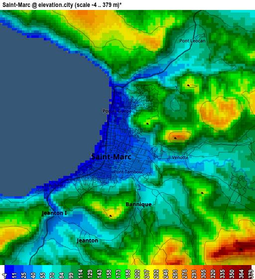
Below is the Elevation map of Saint-Marc, which displays elevation range with different colors. Scale of the first map is from -4 to 379 m (-13 to 1243 ft) with average elevation of 123.9 meters (=406 ft) [note 1]
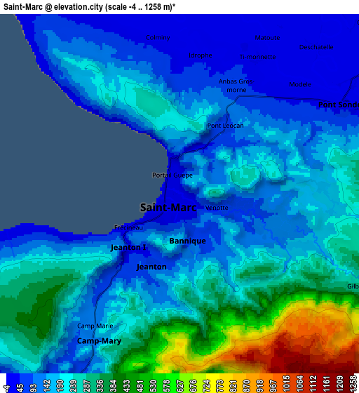
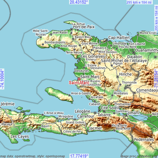
These maps also provides idea of topography and contour of this city, they are displayed at different zoom levels. More info about maps, scale and edge coordinates you can find below images.
| \ | Map #1 | Map #2 | Topo.Map |
| Scale [m] | -4..379 m | -4..1258 m | × |
| Scale [ft] | -13..1243 ft | -13..4127 ft | × |
| Average | 123.9 m = 406 ft | 227.8 m = 747 ft | × |
| Width | 9.23 km = 5.7 mi | 18.47 km = 11.5 mi | 295.5 km = 183.6 mi |
| Height | 9.23 km = 5.7 mi | 18.47 km = 11.5 mi | 295.5 km = 183.6 mi |
| ↑Max Latitude | 19.149709° | 19.191217° | 20.43152° |
| Latitude at center | 19.10819° | 19.10819° | 19.10819° |
| ↓Min Latitude | 19.066661° | 19.025121° | 17.77419° |
| ← Min Longitude | -72.737735° | -72.781681° | -74.10004° |
| Longitude center | -72.69379° | -72.69379° | -72.69379° |
| →Max Longitude | -72.649845° | -72.605899° | -71.28754° |
Nearby cities:
Cities around Saint-Marc sort by population:
• Gonaïves elevation 5 m
37.7 km,  0°
0°
• Verrettes 72 m
24.8 km,  104°
104°
• Désarmes 81 m
34.3 km,  111°
111°
• Dessalines 26 m
25.3 km,  47°
47°
• Gros Morne 219 m
62.6 km, 1°
• Anse à Galets 22 m
35.4 km,  210°
210°
• Mayisad 282 m
58.7 km,  82°
82°
• Plaisance 387 m
59.3 km,  23°
23°
• Cabaret 46 m
50.5 km,  145°
145°
• Marmelade 747 m
57.3 km,  37°
37°
• Grande Saline 3 m
19.2 km,  335°
335°
• Ennery 329 m
47.1 km,  27°
27°
Multilingual:
 En español:
Saint-Marc elevación 16 m.
 En France:
Saint-Marc élévation 16 m.
 Auf Deutsch:
Saint-Marc höhe über dem Meeresspiegel ist 16 m.

Sources and notes:
- [note 1] Map square and city borders are not equal. Map elevation data is calculated only from area inside that square.
- [src 1] Elevation data from geonames database provided with same terms of usage.
- [src 2] The elevation map of Saint-Marc is generated using elevation data from NASA's 3 arcsec (90m) resolution SRTM data.
- [src 3] Base (background) map © OpenStreetMap contributors tiles are generated by Geofabrik and OpenTopoMap.
Copyright & License:
This Saint-Marc Elevation Map is licensed under CC BY-SA. You may reuse any part from this page, if you give a proper credit by linking to this URL:
 More info on terms of use page.